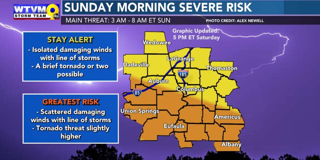

ALERT Day: Rain and storms move in overnight
COLUMBUS, Ga. (WTVM) – It was a cloudy day across the Chattahoochee Valley with afternoon temperatures ranging from the upper-50s to low-70s. This evening, expect the cloudy skies to continue with an isolated shower possible. We have declared an ALERT Day tonight due to the potential for strong to severe storms.
The timing of the threat is between 3AM – 8AM ET with the main concerns being pockets of damaging gusty winds and an isolated tornado threat. With this system moving in during the overnight hours, make sure to have multiple ways to receive alerts if a warning is issued for your area.
Regardless of rain and storms it will be windy tonight and on Sunday with wind gusts between 30-40MPH.
Sunday will not be a complete wash out as the rain and storms quickly exit the Valley; by lunchtime hours expect clearing skies and temperatures cooling throughout the day.
Kicking off the work week on a dry note with sunny skies Monday and morning temperatures in the upper-20s to low-30s and the afternoon in the mid-50s. Wednesday will see the next best coverage of rain, with dry conditions and cool temperatures to follow the mid-week rain.
Copyright 2025 WTVM. All rights reserved.
Most Read
Latest News
Mom of 2 kids who froze to death while sleeping in a van says she asked for help: ‘I’m sorry, but I tried’
Arrest made in Americus shooting that killed 5-year-old and teen
Convicted sex offender charged in Columbus child rape case
Police seek witnesses after child, 10, shot at Columbus restaurant
Lee County man charged with Murder following fatal stabbing on Lee Rd. 147
Toxic mold forces family out of home after experiencing major health complications
College professor found dead at lake, search for missing coach turns into death investigation
Reports: JCPenney to close stores nationwide. Here’s the list
WATCH LIVE: Sunday, February 16 severe weather coverage
Saturday Evening Weather on the Go
Friday Evening Weather on the Go
Mainly Dry on Saturday, Rain/Storms Return Saturday Night
WTVM Weather Kid: Wyatt
Beautiful Valentine’s Day Ahead
Derek’s Thursday Evening Weather On the Go
We’re Sorry!

This website is unavailable in your location.
It appears you are attempting to access this website from a country outside of the United States, therefore access cannot be granted at this time.
Severe weather alert: Squall line may bring tornadoes, strong gusts to north Florida
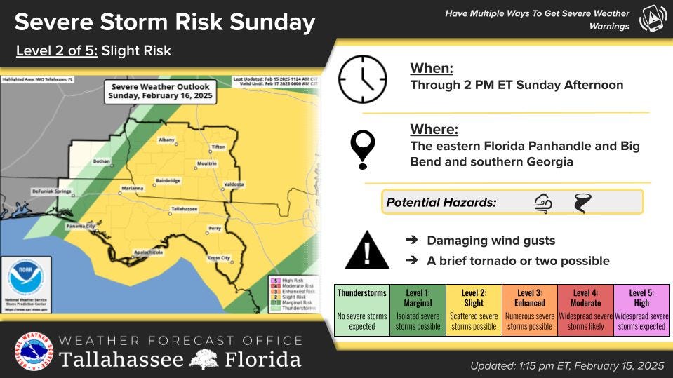
A squall line could bring punishing winds or tornadoes to north Florida and the Tallahassee area overnight and into Sunday morning.
Saturday afternoon, National Weather Service forecasters upped the chances of severe weather for the Big Bend from a marginal risk on a Level of 1 to 5 to a slight risk, a level 2 of 5.
“The main threats will be damaging winds and a few tornadoes,” forecasts wrote on a Facebook alert. They advised north Florida residents, especially in the eastern Panhandle to have multiple ways to get weather warnings over night.
“The greatest chance for strong to severe storms will be over the Central Time Zone counties,” forecasters wrote.
While the squall line is expected to hit the Tallahassee area between 7 and 10 a.m., forecasters warned tornadoes will also be possible in any “rogue showers or storms” that develop ahead of the line.
Already, NWS has posted a wind advisory for between 1 a.m. to 1 p.m. Sunday for expected sustained southwest winds of 15 to 25 mph and gusts around 40 to 45 mph.
“Tree limbs could be blown down and a few power outages may result,” forecasters warned.
The squall line comes ahead of a strong cold front that will usher in chilly temperatures to north Florida. By mid-week, highs are expected to be in the mid to upper 50s. Toward the end of the week, freezing temperatures are possible overnight.