

Live Dallas weather: Severe thunderstorms bring hurricane-force winds to North Texas
DALLAS – A squall line of severe storms swept across North Texas early Tuesday morning, bringing hurricane-force winds, property damage and power outages. The winds caused high-profile vehicles to be pushed over on highways, broken power lines, and downed trees.
As of 7:27 a.m., the number of power outages is now coming down. It is now at more than 274,000 customers without power. The highest number of power outages reported Tuesday morning was more than 318,000.
To report an outage, text OUT to 66267, call 888-313-4747, use the MyOncor app, or select “Report an Outage” located above the map.
Check outages here.
Light Rail and TRE passengers should anticipate delays due to severe weather-related issues throughout the service areas. Please allow for additional travel time in your commute.
A Wind Advisory is in effect until 9 p.m. Tuesday. West to Southwest winds of 20 to 30 mph with gusts up to 50 mph are expected.
All of North and Central Texas will be affected.
Unsecured outdoor items may be blown around in the wind. Driving on area roadways may become difficult, especially for high-profile vehicles. Small tree limbs could break and cause damage.
A Wind Advisory means that sustained winds of at least 20 to 30 mph are expected. Winds this strong can make driving difficult, especially for high-profile vehicles. Residents may wish to take action to secure trash cans, lawn furniture, and other lightweight outdoor objects that may be blown around in the strong winds.
Photo by Brooke Sanchez in Irving
At 5:30 a.m., DFW Airport recorded a wind gust of 74 mph.
At 5:45 a.m., Dallas Love Field reported a wind gust of 78 mph.
Related
FOX 4 Weather Meteorologist Evan Andrews said he’s gotten official reports of straight-line wind speeds as high as 74 mph at DFW Airport and 78 mph at Dallas Love Field.
According to FOX 4 Meteorologist Evan Andrews, the weather sirens will sound for winds in excess of 70 mph. The gusts in some areas were recorded at 78 mph.
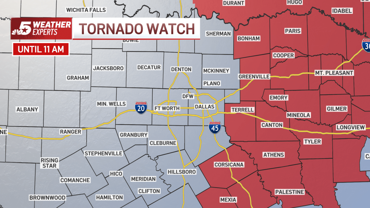
A tornado watch has been issued for North Texas until 11 a.m.
Related
A large part of Texas is expected to see temperatures dip below freezing. Throughout the rest of winter, you will hear meteorologists use terms like warning, watch and advisory, but what do they mean?
Later in the morning into early afternoon, it will turn mainly sunny and very windy. WSW winds could gust to 40-45 mph as very dry air races in, and temps rebound into the low 70s. We could see dust blow as well.
A second cold front sweeps through late day, so winds will shift again along with a few clouds. By Wednesday morning, we’ll be in the 40s with a bit of a wind chill too.
Wednesday will be SUNNY and cool with highs near 60. Diminishing winds will make for a nice early March afternoon.
After a chilly start on Thursday, we’ll rebound into the 60s as south winds start to increase. Sunday will yield to some afternoon cloudiness but otherwise fairly quiet.
DOWNLOAD THE FOX 4 WEATHER APP
Friday will see another SHIFT in the winds. Clouds in the morning will turn to sun as winds become westerly and temps should jump back into the 70s. Fairly warm end to the week.
Ready for another big change? That happens on Saturday. A cold front Friday night will cool us down. At the same time, an upper-level system will race across Texas from the west. That means mainly cloudy skies and a chance for a few showers. With a north wind, we’ll struggle to get out of the 50s in most areas.
That system exits on Saturday night as we turn the clocks forward. By Sunday morning, we’ll have lows in the 30s and even a light freeze possible in northern areas before sunshine helps push us back into the 60s.
The Source: Information in this article is from FOX 4’s Meteorologist Evan Andrews and the National Weather Service.
All the news you need to know, every day
By clicking Sign Up, I confirm
that I have read and agree
to the Privacy Policy
and Terms of Service.
This material may not be published, broadcast, rewritten, or redistributed. ©2025 FOX Television Stations
School Delays
North Texas Power Outages
DART Delays
Wind Advisory
High Wind Reports
Why were weather sirens going off?
Tornado Watch
Tuesday Afternoon
Wednesday & Thursday Forecast
Friday into the weekend
7-Day Forecast
DAILY NEWSLETTER
70+ mph wind gusts cause damage in North Texas
Warning, Watch, Advisory: What’s the difference?
Trending Now
10 injured during Saturday’s NCA All-Star National Championship in Downtown Dallas
Dallas woman allegedly tried to smuggle 9-year-old twins from Mexico under blanket
Texas teen joins Melania Trump in push for anti-revenge porn bill
Family mourns Mesquite 15-year-old murdered on the way home from school
Body of missing Farmers Branch man found in creek near Kaufman County Detention Center
News
Weather
Sports
Good Day
Latest Episodes
About Us
Regional News
WATCH LIVE: Tornado Watch east of DFW, Wind Advisory until 9 p.m. with elevated fire danger
A powerful storm system will bring a chance of strong to severe thunderstorms into Tuesday morning.
A potent storm system moved into North Texas early Tuesday morning setting off outdoor warning sirens and leaving behind damage. While the storms move east, wind and the possibility of wildfires remain for all of North Texas.
A TORNADO WATCH remains in effect for counties east of the Dallas-Fort Worth Metroplex until 11 a.m. on Tuesday. Quick, spin-up tornadoes are possible along with scattered to severe wind gusts to 60 mph along with large hail.
Tuesday afternoon is expected to be dry as the storms move east into East Texas.
Make sure you have the NBC DFW app downloaded to stay ahead of the storm!
The latest news from around North Texas.
A Wind Advisory is in effect for North Texas, including Dallas and Fort Worth until 9 p.m. Tuesday. Expect winds from 20 to 30 mph with gusts up to 50 mph or more.
Please secure all outdoor equipment. Unsecured outdoor items may be blown around in the wind. Driving on area roadways may become difficult, especially for high-profile vehicles. Also, small tree limbs could break and cause damage.
The strong winds and dropping relative humidity will elevate the threat of fire danger to much of North Texas. A Fire Weather Watch has been issued for areas along/south of I-20 and along/west of Highway 281, in Erath, Comanche and Hamilton counties.
The Texas A&M Forest Service is expecting extreme fire danger concerns from DFW to the west. The NWS said the fire threat will be at its maximum in areas where there was minimal rainfall earlier in the morning.
Humidity on Tuesday afternoon is expected to be between 15% and 20%. Strong winds are expected to develop between 20 and 30 mph behind the cold front with gusts to 45 mph.
Drivers are encouraged to avoid activities that could cause sparks, such as dragging towing chains, parking on tall grass, tossing cigarette butts onto dry grass or out of moving vehicles. North Texans are also encouraged to forgo burning trash or leaves.