The Rain is Coming; Here are Driving Tips and Sandbag Locations
San Diego County News Center
Direct To You
The rainy season is finally here in San Diego County, and National Weather Service officials say there could be heavy rains all around the region this week.
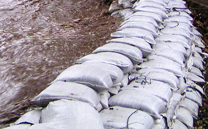
As always, the County and CAL FIRE are offering driving tips to everyone and free sandbags to residents and businesses in the unincorporated areas.
County emergency services and public works road crews say people should stay alert and take precautions and drive carefully on the roads and offered the following tips:
Avoid driving in heavy rain conditions but if the trip is necessary:
As they have in the past, the County and CAL FIRE are providing free bags and/or sand at numerous fire stations for people who live in the unincorporated areas.
Rain can cause flooding and erosion, particularly in areas that are not covered by plants, landscaping, grass and trees. Rain runoff can sweep topsoil, mud, plant material and debris off land and downstream where it can damage homes, clog culverts and storm drains, and flood and damage roadways.
Sand and bags, or bags alone, will be available for unincorporated residents at the fire stations located below.
People should call ahead to double-check availability and remember to bring a shovel to fill the bags. Some stations may have a limited supply.
Residents are encouraged to visit AlertSanDiego.org for information on what to do during an emergency.
Help Shape the County’s Budget
Ballots Go Out to Registered Voters for District One Special Primary Election
Fire Chief Motivates Young Men to Pursue First Responder Careers
Get County News Center stories emailed direct to you.
Help Shape the County’s Budget
Ballots Go Out to Registered Voters for District One Special Primary Election
Luck Flows Both Ways! Spin for a Discounted Adoption Fee
Fire Chief Motivates Young Men to Pursue First Responder Careers
Get County News Center stories emailed direct to you.
County Communications Office
communications@sdcounty.ca.gov
619-595-4633
RELATED STORIES
Post navigation
TRANSLATE
GET UPDATES
LATEST NEWS
ARCHIVE
CONTACT
Be Careful on the Roads
Sand and bags
Bags only
Rain is coming back, San Diego. Here is what to expect

Greg Bledsoe’s evening forecast for March 10, 2025
Rainy weather will return to San Diego County this week, with heavier, wet conditions and moderate winds expected by mid-week through the weekend, the National Weather Service said.
The rain will begin falling early Tuesday and continue on and off through Saturday in most parts of the county with a brief break Wednesday, according to the NWS. The heaviest precipitation is expected to fall Thursday morning.
Current estimates for rainfall totals predict 1 to 1.5 inches in the Santa Ana and San Diego County Mountains, one-half to three-quarters of an inch in the coastal and valley areas, and about one-tenth to one-half inch in the deserts, the NWS said.
Snow levels will start out around 6,000 to 6,500 feet on Wednesday and should lower to around 3,500 to 4,000 feet by Thursday afternoon, the NWS said.
Cooler temperatures were expected this week, with highs in downtown San Diego in the lower 60s Tuesday and Wednesday and the upper 50s Thursday and Friday. The deserts should see highs in the low 60s to mid-70s, and the mountains can expect daytime temperatures in the 40s starting Tuesday and continuing through the week.
A series of swells associated with a couple of storms are expected to arrive this week. Tuesday’s San Diego surf forecast includes a high-risk rip current, with surf from 4 to 6 feet, sets to 8 feet, slight chance of a potential thunderstorm and mixed swell from 220 and 250 degrees. Similar surf is likely Thursday into Friday.
A small craft advisory warning will be in effect from 4 a.m. until at least 6 p.m. Tuesday for coastal waters from San Mateo Point to the Mexican Border and out to 30 nautical miles from San Mateo Point to the Mexican Border extending 30 to 60 nautical miles out including, San Clemente Island.
“Southwest to west winds with gusts in excess of 20 knots likely Wednesday night into Friday, creating conditions hazardous to small craft,” marine forecasters said. “There is a 60% chance of wind gusts to 34 knots Thursday evening 30-60 nautical miles offshore with decreasing chances the closer you get to land.”
Weather officials predict a few showers may linger into Saturday, with potential for another system sometime early next week.
A flood watch will be in effect for San Diego County’s coasts, valleys and mountains from Wednesday evening through Thursday afternoon.
The NWS also issued a winter weather watch from Thursday morning until Friday morning for the county’s mountains.
The rain will begin falling early Tuesday and continue on and off through Saturday in most parts of the county with a brief break Wednesday.
Watches in San Diego County
Local
Catholic Charities of San Diego announces layoffs because of Trump immigration policies
CHP impounds 30 motorcycles after freeway takeover stunt in San Diego County
Trending Stories
Weather Forecast
By City News Service • Published March 10, 2025 • Updated 30 mins ago
This article tagged under:
CUSTOMS AND BORDER PROTECTION
LEMON GROVE
CHULA VISTA
CHP
VISTA
Cold, wet, windy weather moving in as San Diego County nears spring

Spring is near. But this is no time to stow your scarves and sweaters.
A pair of fast-moving Pacific storms will give San Diego County the shivers this week, dropping temperatures far below average and briefly drenching a region that’s in drought, the National Weather Service says.
It’s also possible that snow will fall as low as the 3,500-foot level, and clouds might make it impossible to see a total lunar eclipse on Thursday night.
The first storm was expected to move ashore before dawn Tuesday in North County, then spread south and east, possibly producing 0.10 inches to 0.25 inches of rain at the coast and far more east of Interstate 15.
“It’s going to be showery,” said David Munyan, a weather service forecaster. “Some areas could get a lot more rain than others.”
A second, larger system will arrive Wednesday night and last well into Thursday, delivering 0.25 inches or more inches of precipitation at the coast and an inch in the eastern half of the county. Palomar Mountain and Mount Laguna are likely to have snow by dawn Thursday.
The daytime high temperature at San Diego International Airport will be 60 on Tuesday, 63 on Wednesday and 58 on Thursday. The seasonal average high is 67.
The airport has recorded 2.2 inches of precipitation since the rainy season began on October — 5.57 inches below normal. The entire county is in extreme drought, according to the U.S. Drought Monitor.
The clouds will be moving fairly quickly, but it’s doubtful that skies will be clear at 8:57 p.m. Thursday when a total lunar eclipse begins to unfold above the east-southeast horizon. The moon will be in full eclipse from 11:26 p.m. to 12:31 a.m. Friday. The eclipse will end at 3 a.m.
“You’d probably have to go to the eastern end of Imperial County to see the eclipse,” Munyan said.
Copyright © 2025 MediaNews Group
Hurry, this deal won’t last!