Millions under weather warnings as ‘life-threatening’ floods hit Kentucky, Tennessee
A powerful storm is bringing “life-threatening” flooding to the eastern half of the United States this weekend, according to the National Weather Service.
Millions of Americans are in the path of a storm that is due to hit parts of Tennessee and Kentucky the hardest with several inches of expected rainfall. On tap for the region through Saturday night are severe thunderstorms and torrential downpours that could even produce multiple tornadoes, said AccuWeather severe weather expert Guy Pearson.
Portions of the Ohio Valley, Tennessee Valley and Lower Mississippi Valleys all stand a chance of being hit with widespread showers and thunderstorms as the storm moves eastward to the Appalachians, the weather service said.
Here’s what to know about how the storm could progress.
The “life-threatening flash flooding event” is most dangerous in northwestern Tennessee and western Kentucky, where a high risk of “excessive rainfall” is in place, the weather service said.
The impending storm prompted Kentucky Gov. Andy Beshear to declare a state of emergency Friday.
“We want everyone to be careful,” Beshear said in a statement. “The amount of rain coming down will make it hard to drive, and flash flooding, especially across our roads, can create dangerous conditions.
Heavy rain is causing flooding in our area, and our storm sewer system is currently working at maximum capacity. If you can avoid traveling today, please stay off the roads to keep yourself and others safe. pic.twitter.com/owW6dOX4yZ
— Bowling Green KY (@CityofBGKY) February 15, 2025
As of Saturday afternoon, a nearly 500-mile stretch of flash flood warnings was in effect from eastern Arkansas to eastern Kentucky, according to Accuweather. Urban and hilly areas are particularly prone to deadly flooding where water levels on small streams and roads can rise several feet in minutes.
💧2.5 to 4.5 inches of rain have already fallen over southern Kentucky. Another 2-4 inches are expected tonight. #TurnAroundDontDrown pic.twitter.com/OrZrAneite
— NWS Louisville (@NWSLouisville) February 15, 2025
Water rescues were already taking place Saturday in south central Kentucky between Russellville and Scottsville, where 3.5-4.5 inches of rain had fallen and another 1-2 inches was expected, the weather service reported.
In four western Kentucky counties, between 2 and 3 inches of rain had fallen and up to another 3 inches is possible, the weather service warned Saturday afternoon. Parts of Carlisle, Graves, Hickman and Marshall counties were under a “considerable threat” of flash flooding until 7 p.m.
A rockslide was reported by emergency management officials on I-69 in Kentucky between Dawson Springs and Princeton, reported the weather service in Paducah. The weather service in Morristown, Tennessee said it was receiving reports of mud slides in hilly areas.
Such slides can be more common in winter when plants and shrubs are dormant.
Flash flooding from the torrential downpours is also possible from northeastern Texas to southern West Virginia, western North Carolina and northern and central Georgia.
The weather service’s Storm Prediction Center says severe weather is possible in the Lower Mississippi Valley and central Gulf Coast. The Lower Mississippi Valley is the nation’s largest floodplain, covering more than 24 million acres across portions Arkansas, Illinois, Kentucky, Louisiana, Mississippi, Missouri and Tennessee.
As of Saturday afternoon, heavy rains and flash floods had already started pummeling parts of Virginia, Gov. Glenn Youngkin posed on social media site X.
“Stay alert – don’t fight the water, just leave, and call for help,” Youngkin said.
Heavy rain is hitting Virginia, with flash floods already reported in SWVA. Stay alert—don’t fight the water, just leave, and call for help. First responders, rescue crews, law enforcement, VDOT, and the VA National Guard are deployed. Your safety is our top priority.
— Governor Glenn Youngkin (@GovernorVA) February 15, 2025
Anywhere from 2 to 4 inches of rain could fall through Sunday morning across the region from northern Mississippi and eastern Arkansas to southern Ohio, southwestern Pennsylvania and much of West Virginia.
Many parts of Tennessee and Kentucky are projected to receive 4-8 inches of rain from the storm.
Such intense rainfall, especially when combined with rain that had fallen earlier in the week, poses of risk of causing rivers to rise and flood.
“Moderate to major flooding is forecast for multiple secondary rivers in Kentucky and Tennessee,” according to AccuWeather. “The combined rainfall from last Monday to this upcoming Sunday may reach 20 inches in some locations.”
The flooding risk is expected to lessen heading into the evening as a cold front moves in and storms clear more quickly, according to the weather service. However, as the showers and thunderstorms spread into the east coast from Sunday morning into the afternoon, some areas of the southern Mid-Atlantic are still at risk for isolated flash flooding.
While flash flooding may extend from northern and central Florida to Maryland, Delaware and southern New Jersey, storms should largely wind down by Sunday evening as the front moves into the Atlantic.
Contributing: Dinah Voyles Pulver, USA TODAY
Eric Lagatta covers breaking and trending news for USA TODAY. Reach him at elagatta@gannett.com
This article originally appeared on USA TODAY: Floods swamp Kentucky, Tennessee; millions under weather warnings
‘Life-threatening’ flooding possible in Kentucky, Tennessee
Where are flood watches and warnings in place? See map
How much rain is expected?
Storm to exit into the Atlantic by Sunday evening
Related articles
Related articles
Related articles
In Other News
Woman is ‘tempted’ to sell friend’s concert ticket after she hasn’t paid her back in …
Kate Hudson gives candid answer when asked if her famous family would ever star in a …
Does the envelope budgeting system actually work? These are the pros and cons
I think a recession is coming and want to convert 90% of 401(k) into cash – is this a…
Dessert ‘chips and salsa’ recipe is TikTok’s new viral food trend
NYC coal-oven pizza legend Patsy Grimaldi dead at 93: ‘He was a visionary’
Two teen girls started selling baked goods during the pandemic. Now, ‘Little Sistas T…
The most romantic place in every state
Winter storm Jett to become northeast bomb cyclone with snow, ice, high winds through…
William Ray Lucas, ex-director of NASA center that shouldered much of the blame of Ch…
Former White Sox All-Star, World Series champion Bobby Jenks undergoing stomach cance…
Angels sign Kenley Jansen, Yoán Moncada to 1-year deals
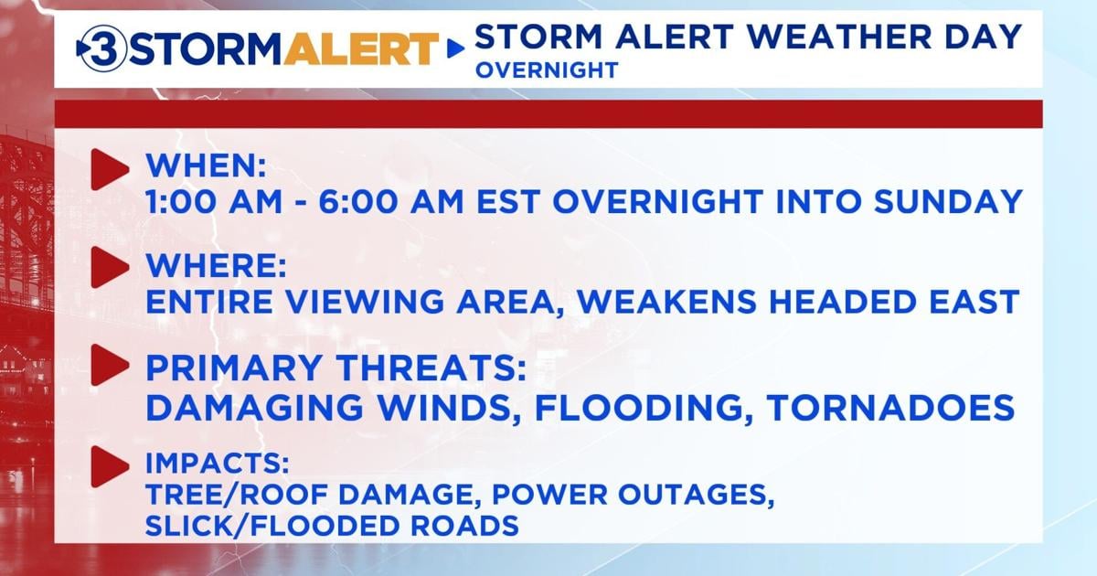
Damaging winds, flooding, and possible tornadoes overnight
Chattanooga
Cloudy
H 53°
L 50°
54°
Today and Sunday are STORM ALERT WEATHER DAYS. Here is what we can expect.
Good Saturday, everyone.
Today and Sunday are STORM ALERT WEATHER DAYS. Here is what we can expect.
TIME FRAME: 1:00 AM to 6:00 AM EST (Overnight into Sunday morning)
THREATS:
– Damaging winds between 50-60 mph, up to 70 mph in the East Tennessee Mountains as the main threat
– Flooding threat, between 1-2 inches of rainfall is expected
– Tornadoes are possible overnight
– Lightning – this risk is just as dangerous as the others!
– Hail risk is low
WHERE:
– Our entire coverage area for damaging winds, flooding, and general thunderstorms
– Tornado threat decreases for our eastern communities past Hamilton County
RISKS:
– Tree and roof damage
– Localized flooded roads and rivers
– Slick roads, avoid traveling during this time frame
– Power outages are likely
– Mud and rock slides
PRECAUTIONS YOU SHOULD TAKE:
– Have weather radios on hand and weather app notifications turned on
– Have a safe space ready in case of a tornado warning
– Bring in any loose items from outside including trash cans
– Charge any electronics you need
– Have flashlights and batteries on standby in case of an outage
– Unplug any expensive electronics in case of a power surge
– STAY INDOORS.
– Do NOT drive or walk through any unknown depths of water, it is NOT worth the risk.
– If you live in a mobile home, find a friend or family member’s place to stay in with secure foundation, or find a storm shelter near you.
Before the severe weather occurs, we can still expect sustained winds between 15-30 mph with wind gusts up to 45 mph. Pop-up showers are likely throughout the evening before the thunderstorms.
The low will be 50. We will hit the temperature high of 57 Sunday around midnight, and then the temperatures will plummet from there. A wind chill between 5-10 degrees colder than the actual temperature can be expected. There is a chance for remaining rain showers Sunday morning to turn into a wintry mix in the afternoon and evening for the northern portions of the Cumberland Plateau and East Tennessee Mountains. About 0.10” of snow is expected, and a light sheeting of freezing rain is possible. This will make roads even slicker. Everywhere else may just see a few flurries.
We will continue to keep everyone updated with the latest forecast. Thank you, and please stay weather-aware.
The Chattanooga area is under a Storm Alert Weather warning. Beginning early Sunday morning and lasting until about 6 AM, strong winds and a potential flood threat are expected to impact the region.
“Only 6 inches of water can sweep a person off their feet,” writes Dallas Bay. “…and just one foot can take an average sized sedan off the roadway.”
According to the Tennessee Emergency Management Agency (TEMA), there are several precautions to take before, during, and after a flooding incident.
Meteorologist
Damaging winds, flooding, and possible tornadoes overnight
Storm Threat Looms: Public Works Prepares for Severe Flooding, Winds, and Tornado Risk
Dallas Bay Fire & Rescue reminds public of flood safety ahead of heavy rainfall
TEMA’s advice for staying safe before, during, and after flooding
LOCAL 3 WEATHER
STORM ALERT WEATHER DAY
Tags
Audrey Shirley
TRENDING NOW
MUST SEE VIDEO
Audrey Shirley’s evening weather
Storm Threat Looms: Public Works Prepares for Severe Flooding, Winds, and Tornado Risk
AAA’s tips for driving in wet road conditions
Sections
Services
Police investigate planters destroyed on Frazier Ave. hours after installation
UPDATE: Investigation began 2 years ago for Chatt Prep teacher arrested for solicitation of minor
UPDATE: Crews rescue 10 people, 14 dogs after homeless encampment trapped in flooding
Chattanooga pastor says viral sermon mentioning violence against Musk was “taken out of context”
Heavy police presence at Riverside Drive Thursday evening
Man who plowed through Frazier Avenue planters found, residents express mixed opinions over additions
UPDATE: Brainerd gas station shooting prompts precautionary measures at nearby school
Closings & delays
Shooting victim suffers life-threatening injuries from shooting at Brainerd gas station
Parents of a child in the Primrose Daycare aggressive patting video speak out
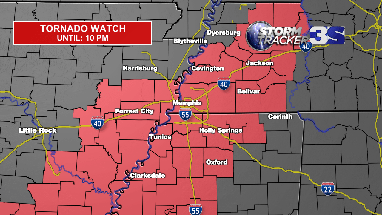
Tornado Warning in effect through Saturday Evening
WREG.com
by: Jake Dalton, Tyler Eliasen
Posted: Feb 15, 2025 / 04:06 PM CST
Updated: Feb 15, 2025 / 05:47 PM CST
Buckle up, it is going to be another wild ride of weather over the next several days.
First off, we have an enhanced risk for severe weather this afternoon/evening with the potential of strong thunderstorms, along with heavy rainfall and a high risk of flooding in spots.
A TORNADO WATCH is now in effect until 10 pm for most of the Mid-South. A watch means conditions are favorable for severe thunderstorms that may produce tornadoes. Now is the time to make sure you have a safety plan with your family and be ready to move to shelter should a warning be issued.
The severe threat will ramp up this afternoon and evening, especially after 4pm. The greatest threat of severe storms (hail, damaging winds, tornadoes) will extend up through the Delta to I-40 and eastward from there. A significant tornado (EF2+) or two can’t be ruled out.
There is a FLOOD WATCH in effect for all of the Mid-South.
Rain will be fairly persistent, especially north of I-40. We are expecting an additional 2-5″ inches of rainfall, with locally higher amounts. Our soils are already saturated, so that means the rainfall will run off and potentially cause some major flooding issues on Saturday.
Once the rain clears Saturday night, we will turn cold and breezy on Sunday.
Even colder air will make its way into the Mid-South around Wednesday – Thursday next week.
Along with that, a storm system will likely sling some moisture over the cold air and produce wintry weather in the area Tuesday night into Wednesday. Now, this is going to be a complex system, an may be a messy mixed bag of precipitation (rain, snow, sleet) over the Mid-South. Stay tuned over the next few days as we begin to iron out those finer details.
Our Weather Experts will be in the Severe Weather Center around the clock tracking the storms in our area.
Copyright 2025 Nexstar Media Inc. All rights reserved. This material may not be published, broadcast, rewritten, or redistributed.
Starbucks new Crema Collection Premium Instant Coffee froths like a cafe beverage.
Walmart has a ton of amazing deals on pet products this week, so you can treat your pet to something nice — without breaking the bank.
The best Byoma skin care products can help strengthen your skin barrier.
SUBSCRIBE NOW