23
by Meteorologist Peter Hall
TOPICS:
After reaching 44 degrees briefly midday Thursday, strong gusty cold winds are bringing colder temperatures, wind chills and lake effect snow for our area through Friday.
Looking at all of the newest information into the CNYcentral Weather Authority weather center, it still looks very likely that portions of the immediate CNY area will receive heavy bouts of lake effect snow alongside gusty winds.
As always, lake effect snow forecasts are difficult, and this one is no exception. There will be a large difference in total snow amounts through Friday evening. The placement and exact intensity of the lake effect snow will be monitored to see if we need to increase or decrease amounts and whether or not to move the bands of snow further north or south.
With that in mind, here is my updated snowfall forecast for this particular event:
New snow between 7:00 PM Thursday & 7:00 PM Friday for the immediate CNY area
New snow between 7:00 PM Thursday & 7:00 PM Friday for much of Upstate NY
Make sure to tune into Today in Central New York first at 4:00 AM Friday to see exactly where the lake effect snow has set up and where it goes next!
With lake effect snow likely in the Syracuse, I thought it would be interesting to look at Valentine’s days in the past.
Here are the warmest, coldest, wettest & snowiest on record for Syracuse:
Warmest, coldest, wettest, and snowiest Valentine’s days on record for Syracuse
Here are the past 6 Valentine’s Days and the top 6 snowiest Valentine’s Days on record:
Valentine’s days in recent years and the top 6 snowiest Valentine’s days in Syracuse
Depending on the exact placement of lake effect snow, Valentine’s Day 2025 could be one of the top 6 on record!
Once the lake effect snow moves northward and ends Friday night, Central New York will have more wintry weather ahead.
Here are our next weather makers:
Our next weather makers
As mentioned above, we will have two new widespread systems coming through our area this weekend.
The first one develops late morning to midday Saturday with some light snow and will become occasionally moderate during the afternoon.
It appears that much of Central New York will probably see 2 to 4 inches of snow through Saturday evening.
A large and stronger system will then move across our area for later Saturday night through Sunday. There continues to be much uncertainty on whether this is an “all snow” event, a snow-mix-rain back to snow event for Saturday night through Sunday. Stay tuned for updates on this.
In addition, a polar plunge of colder wind chills, temperatures and lake effect snow will return Sunday night into next Monday!
For more specifics about all of this, watch my video forecast below:
0 seconds of 0 seconds
Play
Video forecast from NBC3 News Live at 5:00 PM Thursday February 13, 2025
LAWMAKERS
DEALS
TRAFFIC
LEGAL
TRENDING
NEWS IN PHOTOS: “Local”
Heavy snow continues today in Central NY; get ready for more this weekend
This map shows the total snowfall expected through Sunday morning in Upstate New York.National Weather Service
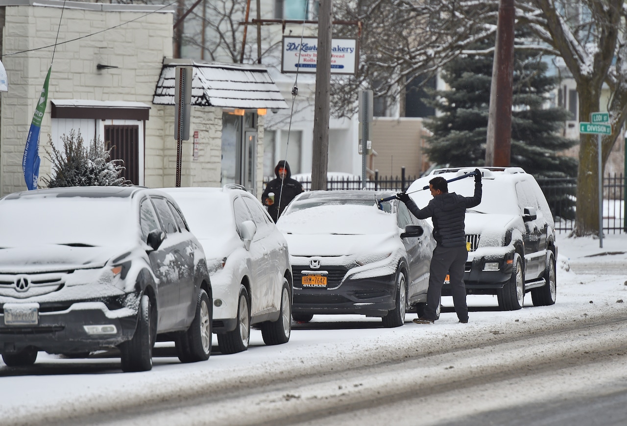
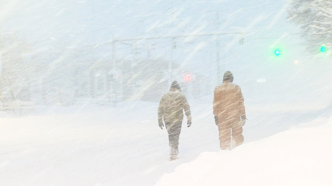
Syracuse, N.Y. — Intense lake effect snow is expected to fall throughout the day today in Central New York, with another foot possible north of Syracuse.
There’s more snow in the forecast this weekend as another storm pummels the region. And a blast of cold air early next week will crank up the lake effect snow machine once again.
During the day today, lake effect snow could fall at a rate of 1 to 2 inches per hour, the National Weather Service said. Wind gusts could reach 25 mph.
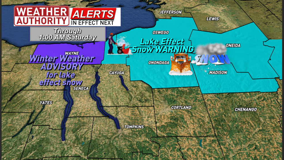
A lake effect snow warning is in effect until early Saturday morning.
The city of Syracuse and Onondaga County have issued travel advisories, reminding drivers to be ready for hazardous road conditions. The village of Phoenix has banned travel this morning. Schools throughout the region have closed or on two-hour delays.
The lake effect snow bands will be narrow, and snowfall could vary widely over short distances. The northern half of Syracuse could see 6 to 8 inches, while the southern half of the city is likely to get only half that much.
Ten to 12 inches is expected in a narrow band across southern Oswego County and northern Onondaga and Madison counties.
“Totals will sharply decrease as you go south in Onondaga and Madison counties and east and north in Oneida County,” the weather service said.
The snow shifts farther north tonight, zeroing in on the Tug Hill before the storm subsides.
The respite will be brief. Another, widespread storm system moves in Saturday morning, bringing snow from west to east.
The weekend storm will bring several inches of snow, but the real issue will be ice. Up to a quarter-inch of ice could accumulate by Sunday afternoon, enough to turn untreated sidewalks and parking lots into skating rinks and bring down tree limbs.
The heaviest ice is expected east of I-81, with southern Oneida and Madison counties getting a quarter-inch or more. Syracuse would likely get just a light glaze of ice, and little to no accumulation in much of Onondaga and Oswego counties.
A quarter-inch of ice could cover the ground and trees by Sunday in parts of Upstate New York.National Weather Service
Arctic air blows in Sunday night, potentially creating even more ice in a rapid flash freeze. Temperatures on Monday and Tuesday are expected to fall into the single digits, and strong winds could generate dangerous wind chills.
Heavy lake effect snow is also expected early next week as the bitterly cold air blows across the Great Lakes.
If you purchase a product or register for an account through a link on our site, we may receive compensation. By using this site, you consent to our User Agreement and agree that your clicks, interactions, and personal information may be collected, recorded, and/or stored by us and social media and other third-party partners in accordance with our Privacy Policy.
Use of and/or registration on any portion of this site constitutes acceptance of our User Agreement, (updated 8/1/2024) and acknowledgement of our Privacy Policy, and Your Privacy Choices and Rights (updated 1/1/2025).
© 2025 Advance Local Media LLC. All rights reserved (About Us).
The material on this site may not be reproduced, distributed, transmitted, cached or otherwise used, except with the prior written permission of Advance Local.
Community Rules apply to all content you upload or otherwise submit to this site.
YouTube’s privacy policy is available here and YouTube’s terms of service is available here.
Ad Choices
GET THE LATEST WEATHER NEWS
A foot of snow and counting on this Valentine’s Day
WSYR
by: Dave Longley, Jim Teske, Kate Thornton
Posted: Feb 13, 2025 / 10:00 PM EST
Updated: Feb 14, 2025 / 07:50 AM EST
SYRACUSE, N.Y. (WSYR-TV) — Heavy lake effect snow is falling across areas southeast of Lake Ontario right now and will last throughout the day Friday.
The Storm Team has received numerous reports from the Fulton, Granby, Pennelville areas of a foot of snow as of 7am Friday, and still coming down hard!
Locations north of the Thruway like Fulton, Phoenix, Baldwinsville, Liverpool, Clay, and Cicero are seeing snowfall rates as high as 2 inches per hour at times causing whiteout conditions and treacherous road conditions for the morning commute.
If are you located in the heavy snow band, plan on at least doubling your morning commute time.
Lake snow begins to weaken a bit Friday afternoon, shifting north of the Syracuse area. Travel should improve around the Syracuse area for your evening commute and if you have Valentine Day plans during the evening.
A corridor of 6 to 12″ of snow falls through Friday southeast of Lake Ontario. The areas to see more than a foot of snow by the end of the day Friday would be areas centered close to the Onondaga/Oswego County line stretching southeast into Northern Madison and Western Oneida Counties. There could be even be some locally higher totals.
Outside the main area of lake effect tonight and Friday, it will be windy and colder over all of Central New York. Winds the first half of the day Friday could still gust to around 30 mph.
More snow (several inches) will fall over a larger area of CNY on Saturday and Sunday which could snarl things up. You can read more about that mess here.
Copyright 2025 Nexstar Media Inc. All rights reserved. This material may not be published, broadcast, rewritten, or redistributed.