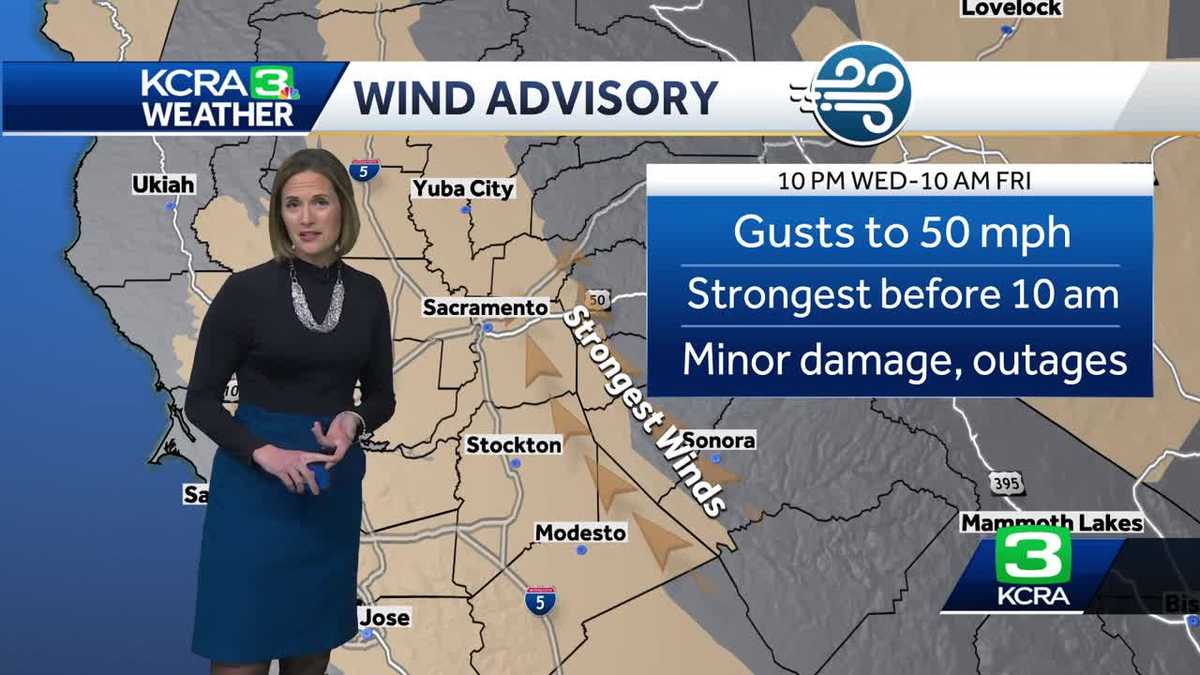
Major changes are heading to Northern California Wednesday night as another storm fueled by moisture from an atmospheric river brings rain, wind and heavy snow that will lead to whiteout conditions in the Sierra.
The KCRA 3 weather team is issuing an Alert Day for Thursday, which is issued when weather conditions could be hazardous.
(Video below: A look at possible wind gusts, rain and snow totals.)
Rain
Rain is expected to move into the Sacramento area Wednesday around 8 p.m. and a little bit closer to 9 p.m. for the Foothills.
The heaviest and most widespread rain will be overnight on Wednesday.
That means ponding and minor roadway flooding are likely for Thursday morning commuters.
Valley rain will break up for a couple of hours late in the morning. There could be scattered downpours and a few strong thunderstorms in the afternoon and evening. A few storm cells could produce small hail and lightning.
Thursday night will be showery in the Valley. Lingering street flooding is possible.
Friday will be quieter for lower elevations with just a couple of early showers.
These are the estimated rain totals from Thursday through Friday:
Wind
Wind will pick up late Wednesday and remain strong before 9 a.m. in the Valley.
Gusts ranging from 40 to 50 mph are possible, especially on the east side of the Valley and into the Foothills. There is also the risk of power outages when heavy rain and strong winds are present.
The gusts will lower to 35 mph in the afternoon and evening.
Snow
Elevations around 4,000 feet and above will start to see snow when it arrives overnight Wednesday. On Interstate 80, that includes areas east of Baxter. On Highway 50, that includes areas such as Kyburz.
Chain controls are up in the Sierra on I-80, Highway 50 and Highway 88.
Snow levels will quickly rise to 5,000 feet early Thursday morning and the snow will be heavy throughout the day.
Sierra travel is highly discouraged Thursday and Thursday night with heavy snow buildup and whiteout conditions. Chain controls are likely on both major highways, which means road officials are expected to lower the speed limit. Extended traffic holds are also possible if conditions become too dangerous.
What to know about adjusted speed limit and chain control installation prices here.
Below are the estimated snow totals from Thursday through Friday:
Looking ahead
Friday will be a calmer day in the Valley with a few showers. Sierra travel will likely continue to be slow even as heavy snow and winds back off. The weekend forecast is dry for all of Northern California.
REAL-TIME TRAFFIC MAP
Click here to see our interactive traffic map.
TRACK INTERACTIVE, DOPPLER RADAR
Click here to see our interactive radar.
DOWNLOAD OUR APP FOR THE LATEST
Here is where you can download our app.
Follow our KCRA weather team on social media
Watch our forecasts on TV or online
Here’s where to find our latest video forecast. You can also watch a livestream of our latest newscast here. The banner on our website turns red when we’re live.
We’re also streaming on the Very Local app for Roku, Apple TV or Amazon Fire TV.
See more coverage of top California stories here | Download our app | Subscribe to our morning newsletter | Find us on YouTube here and subscribe to our channel
Hearst Television participates in various affiliate marketing programs, which means we may get paid commissions on editorially chosen products purchased through our links to retailer sites.
A second winter storm brings cold, rain and snow to millions
Jaclyn Diaz
Pedestrian crosses the street during a snowy day in Vernon Hills, Ill., Wednesday.
The most significant winter storm this year for California is making its way to fire-ravaged communities of Southern California, and threatens to bring potentially deadly, “raging torrents of rockslides and mudslides,” according to National Weather Service forecasts. Meanwhile, millions of Americans across the country faced various threats of heavy snow, wind, extreme cold and tornadoes.
Rain arrives on the West Coast Wednesday with heavy downpours expected late overnight in Central California and moving down to Southern California by Thursday.
“The heavy rain may cause flooding in urban areas and small streams, as well as some minor river flooding,” the National Weather Service’s Weather Prediction Center said. The WPC issued a “Slight Risk” warning for excessive rainfall over Central California to last through Thursday morning.
The risk of flash flooding is highest for communities in or near recently burned areas. Ahead of the storm, wildfire clean up crews worked at “unprecedented” speed to remove structural debris from the destructive Eaton and Palisades fires, according to California Gov. Gavin Newsom’s office.
“It’s possible we get through this rain event without any significant problems, but the potential is there,” said Ariel Cohen, meteorologist in charge at the National Weather Service in Oxnard, according to LAist.
Elsewhere in the nation, wild winter weather threatened Americans from the Midwest to the mid-Atlantic. Communities in Washington, D.C., were digging out of several inches of snow Wednesday morning, while a second winter storm was bringing more snow to the Central Plains into the Great Lakes and a combination of snow, ice and sleet just to the south. Heavy rain and potentially dangerous thunderstorms are also expected to hit parts of the Lower Mississippi Valley and the Southeast, according to the National Weather Service.
James Prince, 4, and Olivia Averyt, 4, sled down a hill at the Capitol, Wednesday, after a snowstorm in Washington.
Between 2 p.m. Thursday and early Friday morning the rain is expected to be the heaviest with rates that could reach 1 inch per hour. The “strong plume of moisture” bringing the wet weather to the West Coast is expected to intersect with the central and southern Sierra Nevada ranges Thursday into Friday, bringing multiple feet of snow.
Even years after a wildfire, areas charred by intense flames can make soil repel water — similar to when rain hits pavement, according to the California Governor’s Office of Emergency Services. Consequently, much less rain is needed to create a flash flood, increasing the potential for mudslides and other debris flows.
The disastrous Eaton and Palisades fires burned thousands of acres of land in Southern California and were only fully contained at the end of January. Those areas burned by the fires and locations situated downhill and downstream from those neighborhoods are especially vulnerable to the coming rain and possible subsequent mudslides.
Officials ahead of the rain urged residents to prepare to evacuate those vulnerable areas. The Santa Barbara County Sheriff’s Office has already issued an evacuation warning for neighborhoods in and near the Lake Fire burn scar.
A property burned by the Eaton Fire is seen Thursday, Feb. 6, 2025, in Altadena, Calif.
Chicago and other parts of Illinois were hit with heavy snow accumulation by Wednesday afternoon in a storm that’s expected to bring the city’s most substantial snowfall so far this season, according to the National Weather Service. This storm is expected to drop around 6 inches of snow in Chicago and 5-9 inches in the Milwaukee area.
“Bursts of heavy snow, accumulating at times to an inch per hour, may lead to hazardous driving conditions and disrupt travel. Heavier snow rates should develop in time for the evening rush hour in Milwaukee, Chicago, Grand Rapids, and Detroit, among other locations,” the NWS cautioned. “Further, a wintry mix of snow, sleet, and freezing rain on the south side of the main snow band will lead to hazardous travel conditions elsewhere in the Midwest and Northeast.”
The skies may be flurry free in the Plains, but the NWS issued serious warnings for parts of Montana, North Dakota and Idaho lasting until Thursday morning with expected overnight wind chills between 45 to 55 degrees below zero. Temperatures that cold could cause frostbite on exposed skin in as little as five to 10 minutes, the NWS warned.
As this storm passes through the Midwest overnight, it’s expected to continue its move further East, bringing close to five inches to a foot of snow to parts of upstate New York and northern New England.
Meanwhile, rain and serious thunderstorms threatened residents in the South. Severe weather is predicted for Southern Louisiana and Western Georgia, according to the NWS’ Storm Prediction Center. An “enhanced risk (level 3 of 5)” was issued for the southern half of Mississippi and Alabama as the potential for large hail, severe winds and tornadoes (including possible EF2 or greater) were heightened.
Why your trick to avoid traffic in Tahoe for ski week won’t work
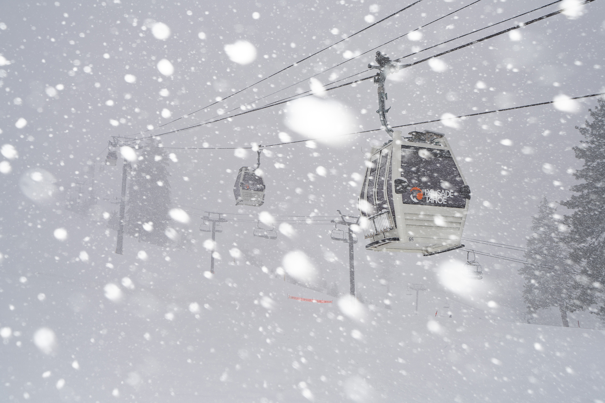
New snow at Palisades Tahoe on Feb. 4, 2025.
Mother Nature is Lake Tahoe’s Valentine this year. A major storm could deliver 2 to 4 feet of snow to the highest peaks along the Sierra Nevada crest by Friday, which is Valentine’s Day.
“We’re sandwiched between some really cold air coming in from the north and also a slight bit of a subtropical intrusion from the south,” said Heather Richards, a meteorologist with the National Weather Service’s office in Reno, which forecasts for Lake Tahoe and the eastern Sierra Nevada.
The storm is slated to coat ski resorts in Lake Tahoe and Mammoth with fresh snow, just in time for a three-day weekend and the beginning of the mid-winter break, sometimes called “ski week,” for many schools in the Bay Area. It’s a “slam dunk for snow,” Richards added.
However, the storm is expected to impact travel to the Sierra Nevada through Friday night. The storm’s timing at the start of a holiday weekend challenges a common refrain from officials to avoid traffic by leaving the Bay Area early on Thursday. Thursday might actually be the worst time to drive to Tahoe this week. For this year’s Presidents Day holiday, Tahoe-bound travelers should consider waiting until Saturday.
“If people can postpone travel until after this storm clears, that’s probably going to be a very safe choice,” Richards said.
New snow at Palisades Tahoe on Feb. 4, 2025.
Local | The secret technology hidden in San Francisco windows
Obscure | The story behind the old Birkenstock building off Highway 101
Culture | A map of where Grateful Dead lived, worked and played in SF
Food | The best fried chicken is at a San Francisco strip club
A winter storm warning goes into effect at 10 p.m. on Wednesday night for the Lake Tahoe Basin and Sierra Nevada region, lasting through 10 p.m. on Friday night.
Heavy snow is expected to fall at lake level in the Tahoe Basin, with accumulations between 10 and 18 inches by Friday night. Higher elevations in the mountains will get more snow, Richards said.
“Along the crest, so the Donner Pass area down through Mono County, anywhere from 2 to 4 feet. Isolated amounts could be a little bit higher than that,” Richards said.
The most intense snowfall will likely occur late on Wednesday night through Thursday, with the potential for snow showers on Friday. Gusts up to 100 mph are expected along the ridges. The storm is expected to taper off on Friday night.
The storm should clear up late Friday and into Saturday. Another storm is forecast to arrive early Sunday morning before daybreak, Richards said. The Sunday storm appears to be warmer, with a rain-snow mix in the Tahoe region.
— Billionaire’s Tahoe hotel cancels summer weddings, sending couples into a tailspin
— For Tahoe’s emergency responders, ski traffic is a public safety hazard
— ‘Homewood is public’: Key vote safeguards public access to historic Tahoe ski area
Julie Brown Davis is the Tahoe editor at SFGATE. She has been writing about mountain towns in the Sierra Nevada for more than 15 years. Julie has written for a variety of publications, from the New York Times and Washington Post to Powder Magazine and Tahoe Quarterly, to name just a few. She grew up on Lake Tahoe’s West Shore. Her corgi is named Squirrel.
About
Contact
Services
Quick Links