First Alert for strong south wind later today and tonight
We’ve had a few bouts of strong east wind this season in the Portland metro area (including a 52 mph gust at PDX with the snowstorm), but not too much southerly wind. That south wind direction tends to drop the most limbs, or whole trees, on powerlines. The last time we saw widespread power outages in the Portland/Salem area was the morning after Christmas (many of us slept through this) when peak gusts reached 40-50 mph in the metro area and Willamette Valley. A similar event happens in the next 18 hours.
I don’t see any flooding issues with this event. The rain over the weekend was mainly good for us, with just a few spots of water ponding, high creeks & rivers, etc…at this moment there are no Flood Warnings on any area rivers. Several rivers got close to flood stage, but again, enough breaks in the rainfall to eliminate a flooding threat. You can see the Clackamas River rise and then fall again once the heavy rain up in the Cascades ended Sunday.
We’ve avoided flooding because rain hasn’t been heavy enough for a long enough period to bring flooding. Seems that ~2.00″ is the average for the past two days in the metro area and down into the valley. When we get a real flood here with multiple flood warnings, you’ll see 2-3″ in just 24 hours in the lowlands. This image only plots amounts greater than 2″, there were plenty below that number.
Remember February was relatively dry up until this point so there was plenty of “storage” in the rivers and ground for these moderate amounts of rain. We have less than 1″ rainfall to go the rest of today through midday Tuesday when we turn dry for 3-4 days.
The surface low approaching the coastline is relatively strong and IS in “the danger zone” inside 130W. But it’ll make landfall well north of us, and this is important, it’ll be weakening as it does so.
Our significant windstorms bring the low pressure center closer, have a deeper central pressure, or involve the low deepening while moving onshore. The satellite loop is a beauty isn’t it? Classic surface low wrapping up offshore. It’s a bit of a “Baby Bomb (Cyclone)” since it’s not dropping that surface pressure more than 20 millibars in 24 hours.
Here’s the surface pressure forecast from the WRF-GFS model (UW) for Noon today, about 980mb central pressure. Notice you don’t see any tight “pressure gradient packing” in the western valleys. Strong wind occurs when you see those lines close together. In fact there’s some easterly wind flowing out of the Gorge at that point running into the southerlies developing in the I-5 corridor
Here’s 8pm. Notice the low is holding about the same pressure, but it’s heading northeast toward Cape Flattery (WA). Oooh, those lines are getting much closer together! Look closely at those isobars across NW Oregon and SW Washington. They are oriented SW to NE over us. Wind is trying to flow more SE than south. It’s windy, but with the low in this position, we don’t really “maximize” the wind in the metro area in this setup..a bit too much of an “easterly gradient”
Then at 2am, the low is weakening rapidly as it moves onto the coastline. Pressure has risen almost 10 mb since peak strength 12 hours earlier. But check out the orientation of the isobars. They have become east-west oriented across NW Oregon and SW Washington. This is a classic setup for “cross-gradient” flow right up the south-north oriented I-5 corridor. Our “best” windstorms feature this “look”. If a 980 low came right across Astoria and over to White Pass, we’d get a major windstorm out of this setup. But that’s not happening this time.
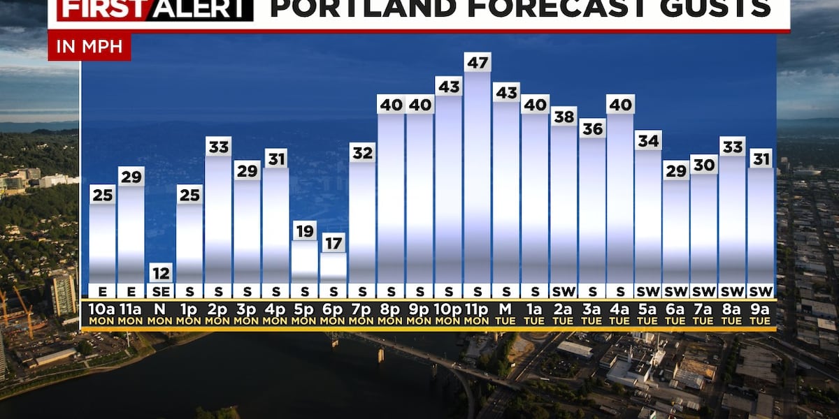
How windy? An old (very general) guide I learned in the 90s was to 3.2xOLM-EUG pressure gradient. So if it’s 14 millibars between Olympia and Eugene you’d get gusts around 45 mph in the valley/metro area. But each storm is different and nowadays we have lots more tools. Our GRAF model does pretty well with these events and for 2 days has been showing gusts 40-50 mph. Looks the same this morning. Notice that initial surge early this afternoon, a break, then the stronger wind a couple hours after sunset.
Here’s the text data for Portland, if correct the peak of this event should be centered on 10pm-Midnight. Wind up around 5,000′ over the metro area during that time is 80 mph from the south or southwest. Having wind aligned at all levels is “helpful” for strong gusts to surface where we live. Also notice the rain isn’t heavy, we have less than 1″ to go tonight, although it will be sloppy evening commute again.
The coastline really gets pounded by this storm, here’s Astoria. Average speeds of 30-35 mph this evening. I noticed just 20 miles offshore the average speeds are around 50 mph! Also notice rainfall is heavy again along the northern coastline overnight.
That’s it for today, I’ll be on the air this evening and make sure you have our app, we often produce quick one-minute videos during these events. Plus you’ll get notified anytime a new blog post is published
Copyright 2025 KPTV-KPDX. All rights reserved.
KEY POINTS
RAIN & FLOODING
DETAILS
Most Read
Latest News
Strongest southerlies in 2 months for metro
SE Portland clothing, vintage store struggles after more than 80 break-ins
Man found dead in travel trailer identified by Portland police
Judge denies bail for former St. Helens teacher accused of sex abuse
40-year-old woman attacked, killed by her own dog, police say
Downed power line starts fire in SE Portland; melting asphalt
Roads reopen after landslide in West Hills, PBOT says
Police investigating armed robbery of bar, customers in NE Portland
All clear in the lowlands after overnight snow
Forecast on track; mainly dry this afternoon then ice/snow tonight
Snow arrives Thursday morning in I-5 corridor
Confidence increasing in a disruptive snow/ice event in lowlands
Widespread snow or freezing rain later this week
No new snow Thursday, but spots of icy roads during morning commute
Wednesday forecast unchanged; lots of wet snow showers for morning commute
Power still out for many in Portland metro after wild storm blows through area
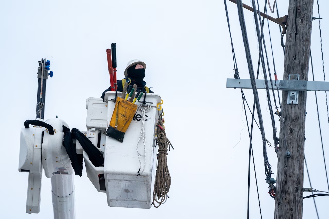
Crews are working to restore power throughout the Portland metro area.Oregonian archive
More than 20,000 Portland-area residents are still without electricity after rain and high winds plunged them into the dark Monday night.
As of 6:30 a.m. Tuesday, Portland General Electric reported 1,110 active outages affecting just over 29,000 customers. Pacific Power, meanwhile, is reporting just a single outage in Portland and about 1,000 outages on the Oregon coast.
RECOMMENDED
No tornado warnings likely Tuesday. Portland sees early showers, then sun breaks Feb. 25, 2025, 3:55 p.m.
Portland weekend weather: Rainy, windy and warmFeb. 22, 2025, 6:27 p.m.
The storm that blitzed the metro area turned the lights off Monday evening for thousands of people in Clackamas, Multnomah and Washington counties – and beyond. Gusts knocked down trees, damaging power lines.
Utility crews continue to work to clear debris and make repairs. Several schools in the area have delayed opening Tuesday because of downed trees and other issues that have blocked roads. The weather is expected to improve throughout the day, with showers giving way to sunshine.
— The Oregonian/OregonLive
Powered by Advance Insights
1 of 5
To understand how we may use the results of this poll, please read our
Privacy Policy and User Agreement. This site is protected by reCAPTCHA and the Google
Privacy Policy and Terms of Service apply.
If you purchase a product or register for an account through a link on our site, we may receive compensation. By using this site, you consent to our User Agreement and agree that your clicks, interactions, and personal information may be collected, recorded, and/or stored by us and social media and other third-party partners in accordance with our Privacy Policy.
Use of and/or registration on any portion of this site constitutes acceptance of our User Agreement, (updated 8/1/2024) and acknowledgement of our Privacy Policy, and Your Privacy Choices and Rights (updated 1/1/2025).
© 2025 Advance Local Media LLC. All rights reserved (About Us).
The material on this site may not be reproduced, distributed, transmitted, cached or otherwise used, except with the prior written permission of Advance Local.
Community Rules apply to all content you upload or otherwise submit to this site.
YouTube’s privacy policy is available here and YouTube’s terms of service is available here.
Ad Choices
47
KATU is declaring a Storm Tracker 2 Weather Alert for high winds along the coast and flooding concerns in the Willamette Valley.
by Bobby Corser
TOPICS:
PORTLAND, Ore. (KATU) — A powerful Pacific storm is taking aim at the Northwest. Heavy rain and strong winds will move across the region Monday afternoon into Tuesday.
LATEST STORM TRACKER 2 FORECAST | SHARE YOUR PHOTOS & VIDEO
“Tonight, I would really be watching for power outages with an increasing south wind,” Storm Tracker 2 Meteorologist Rhonda Shelby said. “If you live up on a ridge or south of Portland, where you see southerly winds, you could see some strong gusts.”
The National Weather Service has issued a Wind Advisory for the entire Willamette Valley and southwest Washington lowlands. A High Wind Warning has been posted for the Oregon and southwest Washington Coast and Oregon Coast Range.
00:00
02:30
KATU
The Wind Advisory will go into effect at Noon on Monday. Winds are expected to ramp up this afternoon and will come from the south, blowing at 20 to 30 mph, with gusts as high as 50 mph.
“Since Friday, the Portland area has seen 1.7 inches of rain and another half-inch to an inch of rain on the way today,” Shelby said.
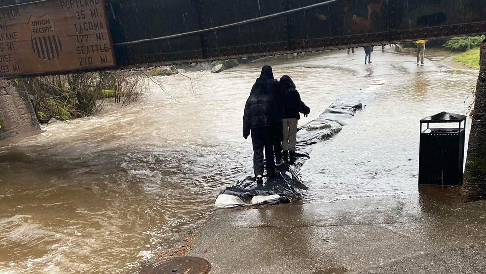
Several landslides have already been reported across the region. In Portland’s West Hills, NW Cornell Road was closed between NW Skyline Boulevard and NW Thompson Avenue, but reopened Monday afternoon. In the Columbia River Gorge, the Historic Columbia River Highway is closed near Rowena because of a rockfall and debris.
The Columbia River Gorge National Scenic Area posted on social media pictures of creeks and streams overflowing their banks.
Due to flooding, the pedestrian path between Multnomah Falls and the large parking lot is now closed.
Just before 2 p.m., NWS Portland issued a Flood Warning for the Luckiamute River near Suver affecting Polk and Benton Counties. “Above 27.0 feet, expect flooding of low lying and agricultural lands in the vicinity of Sarah Helmick State Park, Highway 99W, and Parker Road. Some secondary roads and rural access roads may be flooded at this point. Flooding along Buena Vista Rd near the confluence with the Willamette is also likely, especially if the Willamette is running high,” the alert message said.
Power outages are expected Monday evening and into Tuesday morning. You can check the status of any outage across the region by selecting your power provider in the list below.
KATU Storm Tracker Meteorologists will be tracking the latest developments.