
Fate of New Orleans’ Mardi Gras parades still uncertain as NWS issues High Wind Warning
NEW ORLEANS (WVUE) – Mardi Gras 2025 will go on in New Orleans and the surrounding areas but with major adjustments due to the threat of severe weather.
The Krewe of Zulu will roll on Fat Tuesday (March 4) at 6:30 a.m. Rex says it will follow at 9:30 a.m., but both parades will disband earlier on shortened routes, New Orleans Police Department Supt. Anne Kirkpatrick said. Marching krewes and truck floats will not be permitted. All parades will be required to clear off the streets by 11:30 a.m.
“Parading is over at 11:30,” Kirkpatrick said. “Have a great time, but at 11:30, you’re out of here.”
However, Kirkpatrick said her decision to let parades roll Tuesday was contingent upon the National Weather Service advisory remaining as a High Wind Watch, rather than a more dangerous High Wind Warning. She spoke at a press conference at 3:40 p.m., apparently not realizing that the NWS had already designated around 1 p.m. the more severe High Wind Warning, which is in place Tuesday from 9 a.m. to 9 p.m.
That new information caused city officials to huddle again, with the fate of parades still unclear. New Orleans’ police chief said she was reserving the right to reverse parade authorization if conditions or forecasts further deteriorated early Tuesday morning.
Under the changes initially announced, Zulu will not roll through the historic Treme neighborhood. The krewe will disband at Poydras Street.
Rex will not pass Gallier Hall, where traditionally Rex toasts the mayor of New Orleans. Rex will instead turn down Jackson Avenue and disband.
“If winds are higher than I expected, then I will not have a parade,” Kirkpatrick warned. “I know that would make people mad, but I’m accustomed to having people mad. … We are a city of Carnival, and you don’t just cancel that easily. But public safety will always be No. 1.”
If the parades roll under high wind conditions, Kirkpatrick urged revelers to “pee before you come.” Portable toilets along the routes will be picked up Monday due to time constraints on Tuesday. She also asked paradegoers not to bring umbrellas or tents.
Truck parades will be rescheduled for Sunday, but details on times and routes were not immediately provided by police or city officials.
Rex said in an email shortly before 5 p.m. that its parade will start at 9:30 a.m. at the intersection of Napoleon and South Claiborne Avenues. The parade will follow its traditional route until it reaches Jackson Avenue, where it will turn left at the corner of Jackson and St. Charles avenues. Rex will continue on Jackson until reaching South Claiborne, where it will disband.
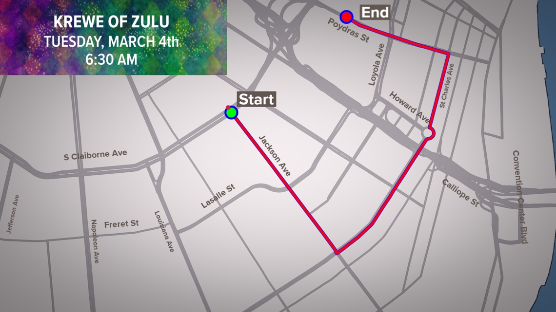
Zulu said in an email just before 6 p.m. that it’s parade would start Tuesday at 6:30 a.m. at Jackson Avenue and South Claiborne Avenue. It will proceed down Jackson to St. Charles Avenue, turn left and go down St. Charles to Poydras Street, then turn sharply left onto Poydras before disbanding at Loyola Avenue.
Jefferson Parish officials canceled all of their Mardi Gras Day parades due to forecasted winds of 40 to 60 mph and an increased risk of severe storms later in the day.
“This is disappointing, but our top priority is ensuring the well-being of everyone in our community,” Parish President Cynthia Lee-Sheng said in a press conference.
+ First Alert: High winds and a severe weather threat on Mardi Gras Day
The first half of the Mardi Gras forecast is quiet, but near lunchtime, conditions deteriorate. Winds are forecast to begin gusting consistently over 40 mph and continue through the afternoon.
Between 4 and 10 p.m., severe storms will enter the area from the west as a storm system blows through.
The severe weather risk will come from the possibility of tornadoes, damaging winds and heavy rains. A separate wind threat will come ahead of this storm line and we’re under a High Wind Watch for that secondary threat.
The Carnival in Covington parade has been moved up to 9:15 a.m. The Krewe of Bogue Falaya will roll at 10 a.m.
The Krewe of Folsom parade has been canceled.
In Lafourche Parish, the Krewe of Chana and Shaka will begin at 8 a.m. in Thibodaux. The Krewe of Gheens will roll at 10:30 a.m. and the Krewe of Neptune will start at 11 a.m. in Golden Meadow.
In Terrebonne Parish, only floats will roll in the Krewe of Houmas parade, which is now starting at 11 a.m. The Krewe of Kajuns will now roll on Monday night following Cleopatra at 6 p.m.
YOUR CARNIVAL AUTHORITY
As officials finalized Mardi Gras plans, Lundi Gras celebrations carried on.
Argus and Zulu royalty greeted each other in Kenner’s Rivertown.
Thousands gathered along the New Orleans Riverfront for the Zulu Lundi Gras Festival at Woldenberg Park.
King Zulu Rodney Paul Mason and Queen Kristen Bonds Mason will arrive via Coast Guard cutter.
French Quarter crowds are also growing, with locals and tourists alike soaking in the Mardi Gras experience rain or shine.
See a spelling or grammar error in our story? Click Here to report it. Please include the headline.
Subscribe to the Fox 8 YouTube channel.
Copyright 2025 WVUE. All rights reserved.
SPONSORED
Most Read
Latest News
High winds and severe weather concerns prompt officials to make changes
Motion Analysis System Proves to be a Great Tool for Patients Needing Physical Therapy
Southern University student dead after off-campus fraternity ritual
One injured by ‘accidental’ gunshot on Bourbon Street, NOPD says
LSU student among 2 dead after crash on campus
Michelle Trachtenberg, ‘Buffy the Vampire Slayer,’ and ‘Harriet the Spy’ star, dies at 39
Tractor pulling Mardi Gras float tips over on New Orleans interstate
Southern University student dies after off-campus fraternity ritual, campus activities halted
Five shot after Mardi Gras parade in Franklinton, police say
Heavy crowds turn out Lundi Gras night for Proteus, Orpheus parades
Rex, King Zulu meet as Lundi Gras revelers fill New Orleans’ French Quarter
Rodney Mason Jr., Kristen Bonds Mason honored to serve as Zulu’s King and Queen
Four cultural krewes team up on Lundi Gras for Bayou San Juan Social Club celebration
High winds during 1970 and 2008 Mardi Gras
Uptown crowds awaiting Proteus, Orpheus parades
Wind threat forces major Mardi Gras parade changes
Triple-threat storm bears down on central and southern US, disrupting Mardi Gras celebrations and bringing blizzard warnings
More than 55 million people across the central and southern US are at risk of severe weather on Tuesday as a violent storm sweeps across the country, bringing the potential for blizzard conditions, tornadoes and fire weather.
The dangerous storm is the first major weather event after staffing at the National Oceanic and Atmospheric Administration and its National Weather Service was slashed by the Trump administration –– cuts scientists say will have dangerous consequences for the safety of the American public. Around 800 employees were laid off across NOAA last week.
RELATED ARTICLE
How Americans will feel the impact of Trump’s weather forecasting layoffs
The powerful storm comes amid Mardi Gras celebrations across the south. In New Orleans, officials rushed to reschedule Mardi Gras day events and shorten parade routes to avoid the potentially destructive weather, according to the Associated Press. A high wind warning is in effect for the city from 9 a.m. to 9 p.m. local time on Tuesday as winds are expected to be sustained at 20 to 30 mph with gusts over 50 mph possible.
A tornado watch was issued for parts of Texas and Oklahoma until 5 a.m. local time Tuesday, with nearly 3 million people affected. Winds up to 70 mph and hail up to 1.5 inches in diameter are also possible as the storm continues to ramp up.
By later Tuesday morning, the storm will increase in intensity as it moves east –– threatening the Lower Mississippi River Valley with strong tornadoes, gusty winds, large hail and heavy rainfall. These storms are expected to last into Tuesday night, which can lead to especially dangerous nighttime tornadoes.
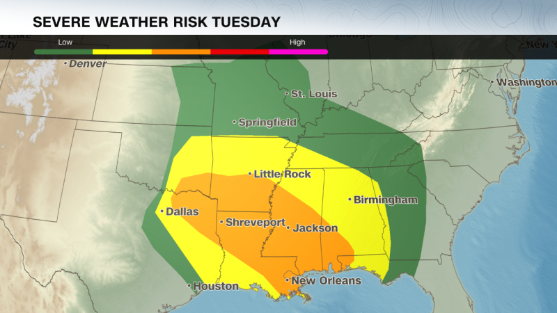
Northern Louisiana, central Mississippi and southern Arkansas will likely experience the worst severe weather Tuesday. Some strong tornadoes, wind gusts over 74 mph, and large hail are possible for cities like Shreveport, Louisiana and Jackson, Mississippi. These storms will likely bring heavy rainfall totaling as high as 3 inches.
A lower threat for severe storms will spread from eastern Texas to western Georgia, extending north through most of Missouri. The lower threat of storms could bring isolated tornadoes, gusty winds and hail to Memphis, New Orleans, Baton Rouge, Atlanta, Dallas, St. Louis and Kansas City.
Officials in New Orleans are keeping a close watch on the coming storms. Some Mardi Gras parade times have been moved and durations shortened as police look to ensure that the hundreds of participants and dozens of floats move along quickly this Fat Tuesday — before winds pick up, the Associated Press reported.
Gusts in New Orleans could reach 60 mph, the National Weather Service said, warning that Mardi Graf floats “could become unstable” amid the ferocious winds.
Two of the city’s largest parades — organized by the Krewe of Zulu and the Krewe of Rex — were still scheduled for Tuesday morning, according to CNN affiliate WVUE. But both parades will follow shortened routes, and police are giving revelers a hard out.
“Parading is over at 11:30 (a.m.),” New Orleans Police Superintendent Anne Kirkpatrick said Monday. “Have a great time, but at 11:30, you’re out of here.”
Kirkpatrick warned she will pull the plug on festivities entirely if the weather worsens. “I hold that trump card in which I will not hesitate to cancel — I won’t do it lightly, but I will do it,” she said.
Officials have already taken that step in neighboring Jefferson Parish, where at least two parades have been canceled because of the expected high winds.
“Loose items could get blown away and high-profile vehicles, including Carnival floats, will have dangerous crosswinds,” the parish said in a statement released Monday.
“This is disappointing, but our top priority is ensuring the well-being of everyone in our community, and we must always prioritize safety above all else,” Jefferson Parish President Cynthia Lee Sheng said. The parish said it will work with the krewes to try to reschedule the parades.
The strong March storm is bringing a different threat to the central US. Snow has already started to fall on the Rocky Mountains and winter weather alerts blanket the region.
In the Denver Metro area, a mix of rain and snow was seen Monday and was expected to continue, according to the National Weather Service. A blizzard warning is in effect from midnight Monday to 2 p.m. local time Tuesday for parts of Colorado’s Elbert and Douglas counties above 6,000 feet.
Some blizzard conditions are also expected across parts of the Central Plains beginning Tuesday morning, with snowfall totals potentially reaching a foot. Winds could gust as high as 65 mph, which could cause blowing snow and rapid drops in visibility. Across the higher elevations of Colorado, snowfall totals over a foot are also possible.
Snowfall will eventually move into parts of the Midwest by Tuesday evening, where winter weather alerts will be in effect for parts of Iowa, Wisconsin and Minnesota beginning Tuesday evening. Here snowfall of 2-7 inches is possible through Wednesday afternoon.
A massive dust storm, meanwhile, swept over swaths of New Mexico, Texas and Mexico on Monday morning, bringing violent winds and cloaking roadways in near-zero visibility.
Officially called a haboob, the fast-moving wall of dust and debris prompted New Mexico officials to close parts of Interstate 10, where the sudden curtain of low visibility appears to have forced some vehicles off the road.
Video taken by a passing truck driver near the city of Deming, New Mexico shows emergency vehicles positioned around a tangle of stopped vehicles, including tractor trailers and an RV-towing pickup truck. Debris is seen scattered across the highway.
“You can see where everything got blown off the road,” truck driver Toby Bogard said in the video shared with CNN. “I hope everyone is alright, but if you’ve never seen a sandstorm called a dust storm out here, this is one.” he added.
Katlyn Stephens and her family were driving on Highway 54 from New Mexico to Texas on Monday morning when their car was suddenly engulfed by the dust storm.
“It was just crazy, we just coasted through,” Stephens told CNN. “It wasn’t until we went through a couple of hills that we knew we were going into something crazy.”
Stephens said her husband, who was at the wheel, was cautious of what was ahead –– occasionally stepping on the brakes to avoid a crash.
The dust storm is expected to worsen fire conditions in the Southern Plains, where strong winds, dry air and ongoing drought are already present.
More than 8 million people across Oklahoma, Texas and New Mexico are under red flag warnings. Parts of western Texas are under an exceptional drought –– the highest level from the US Drought Monitor. If any new fires start, they may spread out of control, the monitor warns.
Central and southwestern Texas are expected to be at the highest risk of fires Tuesday, according to the National Weather Service, which issued an “extremely critical” fire threat for the region. Southeastern New Mexico has also been raised to a “critical” fire weather alert.
Cities like San Antonio and Austin could experience gusts up to 60 mph and single-digit humidity levels through the day, further heightening the danger of fires.
CNN’s Gene Norman contributed to this report.
© 2025 Cable News Network. A Warner Bros. Discovery Company. All Rights Reserved.
CNN Sans ™ & © 2016 Cable News Network.
Mardi Gras makes way for storms
Meanwhile in the Rockies…snow
Dust storm blinds drivers in the Southwest
Up next
Most read
MORE FROM CNN
NEWS & BUZZ
Krewe of Zulu 2025 parade route
NEW ORLEANS — The 2025 Carnival season kicked off on January 6, and Krewe of Zulu is set to roll on Mardi Gras Day, Tuesday, March 4, at 6:30 a.m.
With high winds expected, officials moved up the parade’s start time.
According to Darren Mire, spokesperson for Zulu, Zulu’s route will also change.
The parade starts at South Claiborne and Jackson Avenue. It then goes down Jackson until it reaches St. Charles Avenue, and then down St. Charles until it reaches Poydras Street. It turns onto Poydras Street instead of Canal and ends at Loyola Avenue.
No marching bands or other parade elements will be included.
“The decision to alter our normal Zulu tradition was not an easy one,” says Zulu President Elroy A. James,” the safety of the citizens of New Orleans, our visitors and the Zulu membership is of the utmost importance to our organization so I am sure that it is the right decision.”
Here is the full parade route:
WWL-TV presents the 2025 Mardi Gras Parade Tracker. We are New Orleans’ premier Mardi Gras parade tracking service. We cover more parades in more areas of the city than any other app available on the market.
Here’s where to download the WWL-TV parade tracker for your phone:
[Click here to download for IOS]
[Click here to download for Android]
How do we do it? The short answer is: brute force. We deploy an army of dedicated, warm-blooded (and sober) human beings with GPS devices to walk the entire parade route of every parade we track. WWL physically tracks all of the biggest parades during Mardi Gras starting with Joan of Arc and ending with Rex on Mardi Gras day. Whether you are Uptown or in the French Quarter, in Metairie or on the West Bank, Chalmette, Houma, Thibodaux, or Covington, you can count on us to provide the exact location of the parade you want to see.
Our App includes parade schedules, routes, and real-time GPS location.
Click here to report a typo.
► Get breaking news from your neighborhood delivered directly to you by downloading the new FREE WWL-TV News app now in the IOS App Store or Google Play.
IN OTHER NEWS