Several inches of snow expected across Middle Tennessee
NASHVILLE, Tenn. (WSMV) – A First Alert Weather Day is in effect through Wednesday with accumulating snowfall expected across the Midstate and southern Kentucky. Extreme cold following Thursday and Friday prompting two more First Alert Weather Days.
Have weather pictures or videos? Share them here.
Download the WSMV 4 First Alert Weather app for iPhone or Android, so you can stay informed on the go and in between newscasts. We share custom videos, plus you can choose to get messages from us on the latest conditions and forecasts.
THROUGH TOMORROW:
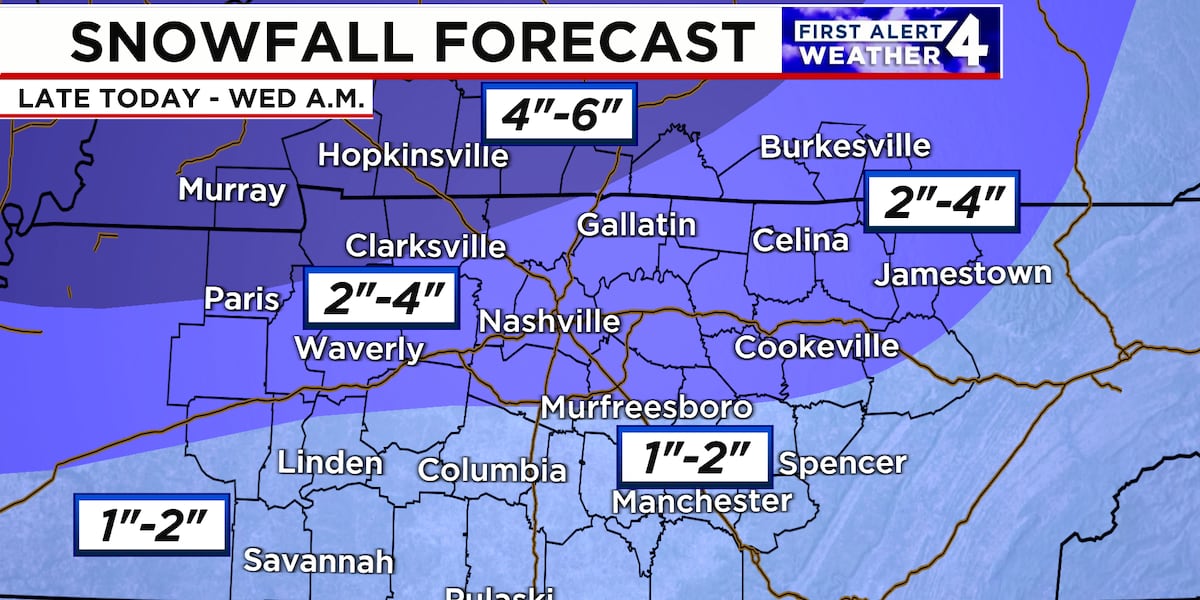
Snow arrived across Middle Tennessee overnight. Snow will expand and intensify for a few hours before tapering off to just flurries and snow showers by early Wednesday morning. Snowfall totals will range from 1″ to 2″ over southeastern Middle Tennessee to 2″ to 4″ along the I-40 corridor. Farther north over southwest Kentucky and northwest Middle Tennessee, 4″ to as much as 6″ of snow will be possible.
Another batch of snow showers will move through late tomorrow night through early on Thursday. For most, this won’t amount to anything. On the Cumberland Plateau, however, an additional 1/2″ to 1″ will be possible in isolated occurrences.
FIRST ALERT WEATHER DAY – THURSDAY AND FRIDAY:
A bitter cold is expected to return to Middle Tennessee for the second half of this week.
A Cold Weather Advisory runs from midnight Thursday through 10 am Thursday. The wind chill early Thursday will be below zero for many. Thursday will be a breezy and frigid day. Sunshine will return during the afternoon.
Expect temperatures in the teens and single digits Thursday morning and only topping off in the 20s Thursday afternoon. Clouds will be tough to break on Thursday, but we should be able to sneak in some sunshine at times.
Extreme cold will follow the snow!
Lows Thursday night and into Friday morning will drop into the single digits across most of Middle Tennessee and Southern Kentucky. Temperatures will get back near that freezing mark by Friday afternoon under a partly cloudy sky.
THIS WEEKEND:
Warmer weather will return Saturday and Sunday with highs back in the lows 40s Saturday and well into the 40s on Sunday. Saturday a passing sprinkle or flurry will be possible. Sunday will be partly cloudy.
NEXT WEEK:
It will be partly cloudy Monday and Tuesday and warmer with a high in the upper 50s on Monday and low 60s on Tuesday.
Copyright 2025 WSMV. All rights reserved.
Most Read
Latest News
Bitterly cold air follows the snow
Winter Storm Warnings issued for parts of Tennessee
Midstate schools close ahead of winter storm
First Alert Weather Day – Snow causing travel impacts
Widespread snow followed by dangerous cold
Accumulating snow starts this evening
Child shoots, kills 2 home intruders in self-defense, police say
Arrest made in deadly Franklin shooting
First Alert Weather Day – Snow causing travel impacts
Snow ends, dangerous cold returns
Early Wednesday morning weather update
‘Stay home’: Clarksville reports nearly 50 crashes as snow moves in Tuesday night
Several inches of snow expected across Middle Tennessee
Winter weather tool kit: Power outage maps, monitoring TN traffic, flight delays, more
Accumulating snow starts this evening
403 ERROR
The request could not be satisfied.
Winter storm bringing snow and dangerous cold follows
WKRN News 2
by: Marcus Bagwell, Shelby Mac, Danielle Breezy
Posted: Feb 18, 2025 / 06:19 AM CST
Updated: Feb 18, 2025 / 11:39 PM CST
NASHVILLE, Tenn. (WKRN) — A Winter Storm Warning is in effect through Wednesday morning for counties generally along the Interstate 40 corridor and northward. A Winter Weather Advisory is in effect for our counties below I-40. Accumulating snow is expected for all, with heaviest totals north and northwest, and lower totals south toward the Tennessee and Alabama state line.
Snow will continue overnight and move out by mid-morning Wednesday.
As far as snow amounts go, 2 to 4 inches of snow are expected across Nashville and much of the north half of Middle Tennessee. 4 to 6 inches are likely for Clarksville and most of Southern KY. Our southern counties will see a coating to 2 inches of snow. The least amount will fall along the Tennessee/Alabama state line.
This snowfall will likely affect travel starting Tuesday night. Also, temperatures are forecast to remain below freezing through Saturday morning, so the snow will stick around for several days and continue to impact the roads.
Then, behind the snow dangerous cold arrives. A Cold Weather Advisory is in effect for all of Middle TN and Southern KY starting late Wednesday night through 10 a.m. Thursday. Wind chill values will be below zero Thursday morning!
We could be near record lows on both Thursday and Friday morning. Remember the 4 P’s: People, Pets, Pipes, and Plants!
Don’t forget to take the power and reliability of the WKRN Weather Authority with you at all times by downloading the News 2 Storm Tracker app.
Copyright 2025 Nexstar Media Inc. All rights reserved. This material may not be published, broadcast, rewritten, or redistributed.
These stylish clutches will fit essential items and tight budgets.
Walmart has its own version of the cult-favorite West Elm swivel chair that’s only $250.
If you want to be sure you’re never exposed to any lead while sipping on your favorite beverages, why not choose a completely lead-free tumbler from Owala?
SUBSCRIBE NOW
SUBSCRIBE NOW