The latest breaking updates, delivered straight to your email inbox.
We are waking up to some wet and snowy conditions, depending on where you are in Iowa. Temperatures have stayed mostly above freezing in Des Moines and along the I-80 corridor.
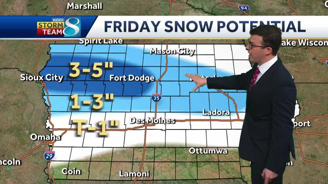
This means the main precipitation that has fallen overnight into the early morning is just rain. Southern Iowa will mostly see rain chances through the rest of the day. Farther north toward Highway 30 and Highway 20, we are seeing more heavy and wet snow which will lead to slick road conditions yet again through the morning.
Interactive Radar | Weather Alerts
There is still a possibility for the rain to switch to snow over the morning hours along I-80, which is why there still is an active winter weather advisory in places west of Des Moines. However, most of the snow will fall north of I-80. Accumulations will mostly range from 1 to 4 inches with some select locations picking up around 6 inches in the northwestern quadrant of the state.
The precipitation chances will start to wrap up through the early afternoon and the evening should be much calmer and clearer. Additional melting will continue as highs will be around and above the freezing point for all of Iowa. We will cool back into the 20s overnight and rebound into the 40s and 50s for the weekend highs. Areas that have seen more snow this week will be lagging with the temperatures for both Saturday and Sunday. Highs will return to the 60s leading to dramatic melting for the northern half of the state early next week. We are looking at a decent dry and warm stretch next week. However, we are keeping an eye on a possible windy and wet system for next weekend.
Today: A rain snow mix through the day. Temps nearly steady in the mid-30s. Winds NE at 10 to 20 mph.
Tonight: Partly cloudy. Low 24F. Winds NW at 10 to 15 mph.
Tomorrow: Sunny. High 49F. Winds W at 10 to 15 mph.
Tomorrow night: Clear skies. Low 29F. Winds W at 5 to 10 mph.
Sunday: Mostly sunny skies. High 56F. Winds WSW at 10 to 15 mph.
Sunday night: A mostly clear sky. Low 35F. Winds WSW at 5 to 10 mph.
Hearst Television participates in various affiliate marketing programs, which means we may get paid commissions on editorially chosen products purchased through our links to retailer sites.
Share
GET LOCAL BREAKING NEWS ALERTS
Iowa weather forecast
Recommended
TOP PICKS
TOP PICKS
KCCI DES MOINES
Quiet and seasonable into the weekend – Chris

What a beautiful start to the day! After a morning of sunshine and highs reaching 40 degrees, the snow has already seen some significant melting after our recent winter storm. This afternoon, clouds rolled in, but the break from bitter cold continues.
Tonight will be chilly, dropping into the upper teens, but Friday brings more sunshine and another day near 40. The real warm-up kicks in this weekend, with highs soaring into the upper 40s Saturday and mid-50s Sunday. By Monday? We could be flirting with 60!
This stretch of mild weather is giving us a taste of spring. Enjoy it— March can always have a few surprises up its sleeve!
Enjoy the evening and take care!
– Meteorologist Chris Reece
Any person with disabilities who needs help accessing the content of the FCC Public File may contact KSTP via our online form or call 651-646-5555
This website is not intended for users located within the European Economic Area.
© 2025 KSTP-TV, LLC
A Hubbard Broadcasting Company