
Live Dallas weather: Tornado watch, damaging winds in North Texas
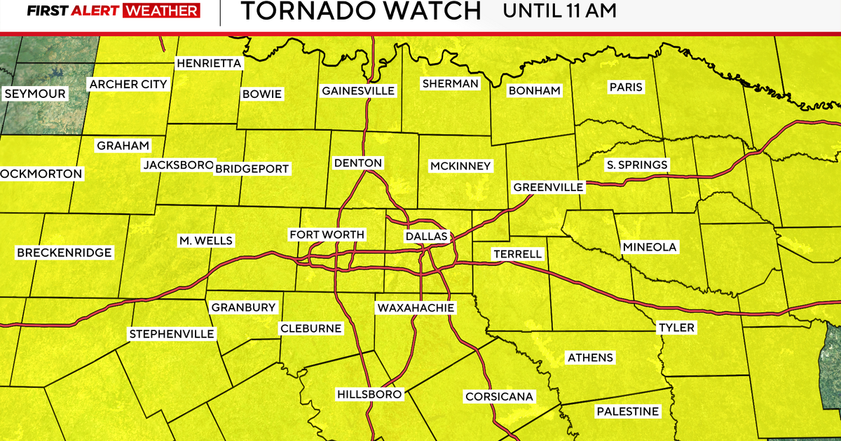
DALLAS – A tornado watch has been issued for North Texas until 11 a.m.
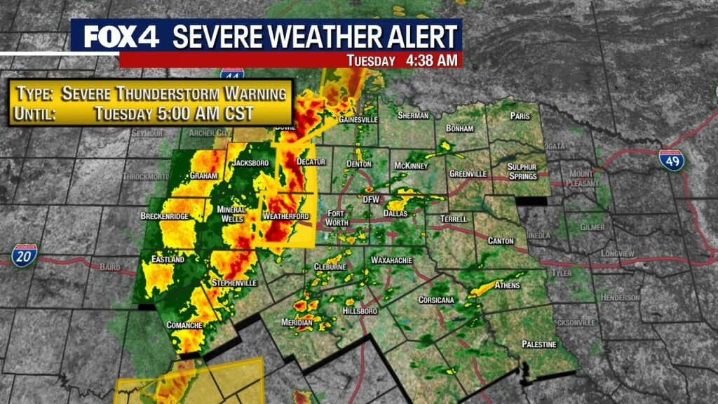
The National Weather Service in Fort Worth has issued a Severe Thunderstorm Warning just before 4 a.m. for Eastern Young County, Wise County, Jack County, Parker County and Palo Pinto County until 5 a.m.
Severe thunderstorms were located along a line extending from Loving to Graford to Strawn, moving east at 55 mph.
HAZARD…60 mph wind gusts and penny-size hail.
The severe thunderstorm warning for Montague and northwest Cooke Counties until 4:45 a.m.
Related
A large part of Texas is expected to see temperatures dip below freezing. Throughout the rest of winter, you will hear meteorologists use terms like warning, watch and advisory, but what do they mean?
This squall line is blowing up to the west and is racing NE.
We expect severe storms to be in the Metroplex from 5-7 a.m. The most active weather will last until about 10 a.m.
The main risks are still high winds, and brief spin-up tornadoes on wavy line segments.
To report an outage, text OUT to 66267, call 888-313-4747, use the MyOncor app, or select “Report an Outage” located above the map.
Check outages here.
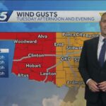
A Wind Advisory is in effect until 9 p.m. Tuesday.
West to Southwest winds 20 to 30 mph with gusts up to 50 mph are expected.
All of North and Central Texas will be affected.
Unsecured outdoor items may be blown around in the wind. Driving on area roadways may become difficult, especially for high-profile vehicles. Small tree limbs could break and cause damage.
A Wind Advisory means that sustained winds of at least 20 to 30 mph are expected. Winds this strong can make driving difficult, especially for high profile vehicles. Residents may wish to take action to secure trash cans, lawn furniture, and other lightweight outdoor objects that may be blown around in the strong winds.
Later in the morning into early afternoon, it will turn mainly sunny and very windy. WSW winds could gust to 40-45 mph as very dry air races in, and temps rebound into the low 70s. We could see dust blow as well.
A second cold front sweeps through late day, so winds will shift again along with a few clouds. By Wednesday morning, we’ll be in the 40s with a bit of a wind chill too.
Wednesday will be SUNNY and cool with highs near 60. Diminishing winds will make for a nice early March afternoon.
After a chilly start on Thursday, we’ll rebound into the 60s as south winds start to increase. Sunday will yield to some afternoon cloudiness but otherwise fairly quiet.
DOWNLOAD THE FOX 4 WEATHER APP
Friday will see another SHIFT in the winds. Clouds in the morning will turn to sun as winds become westerly and temps should jump back into the 70s. Fairly warm end to the week.
Ready for another big change? That happens on Saturday. A cold front Friday night will cool us down. At the same time, an upper-level system will race across Texas from the west. That means mainly cloudy skies and a chance for a few showers. With a north wind, we’ll struggle to get out of the 50s in most areas.
That system exits on Saturday night as we turn the clocks forward. By Sunday morning, we’ll have lows in the 30s and even a light freeze possible in northern areas before sunshine helps push us back into the 60s.
The Source: Information in this article is from FOX 4’s Meteorologist Evan Andrews.
All the news you need to know, every day
By clicking Sign Up, I confirm
that I have read and agree
to the Privacy Policy
and Terms of Service.
This material may not be published, broadcast, rewritten, or redistributed. ©2025 FOX Television Stations
Tornado Watch
Severe Thunderstorm Warning
Latest Update
Power Outages
Wind Advisory
Tuesday Afternoon
Wednesday & Thursday Forecast
Friday into the weekend
7-Day Forecast
DAILY NEWSLETTER
Warning, Watch, Advisory: What’s the difference?
Trending Now
The Brief
Rapper BigXthaPlug arrested for marijuana possession in Arlington
Fight inside Kay Bailey Hutchison Convention Center causes chaos, suspension of NCA cheer event
Dallas weather: Rain, storms expected Sunday night
Texas man transporting 30 pounds of marijuana, THC from New Mexico into Texas arrested: DPS
10 injured during Saturday’s NCA All-Star National Championship in Downtown Dallas
News
Weather
Sports
Good Day
Latest Episodes
About Us
Regional News
North Texas under tornado watch until 11 a.m. Tuesday
By Julia Falcon
Updated on: March 4, 2025 / 4:30 AM CST / CBS Texas
Severe storms entered North Texas in the early morning hours Tuesday, prompting several weather advisories.
The National Weather Service issued a tornado watch for all of North Texas until 11 a.m. Tuesday.
Several severe thunderstorm warnings are also in effect across parts of North Texas until 5 a.m., including Wise, Parker, Jack and Palo Pinto counties.
At 4 a.m., the line of storms moved quickly across North Texas, at 40 mph. The storms brought a lot of lightning with them.
CBS News Texas meteorologists issued a First Alert Weather Day for Tuesday due to the strong, severe storms. Damaging winds and large hail are the main threats with these storms.
Julia Falcon is a digital content producer at CBS News Texas. Julia has previously written for news outlets across Dallas-Fort Worth like the Denton Record-Chronicle, D Magazine, 1080 KRLD and 105.3 The Fan. She covers a span of topics, focusing on sports and trending topics. Every week, Julia produces a show called “Eye on Trending,” where she answers top trending questions.
© 2025 CBS Broadcasting Inc. All Rights Reserved.
©2025 CBS Broadcasting Inc. All Rights Reserved.