![]()
First Alert Weather Day
![]()
The First Alert Weather Team is tracking heavy rainfall for Monday morning’s commute.
A flood watch is in effect for most of our viewing area.
Showers will lighten up by lunchtime. But a few isolated showers may redevelop by the afternoon as the system moves east.
>>> STREAM ACTION NEWS JAX LIVE <<<
[DOWNLOAD: Free Action News Jax app for alerts as news breaks]
Read: Upcoming phase of CR210 widening project causing neighbors new headaches
Expect highs in the 60s in Southeast Georgia, and lower to mid 70s in Northeast Florida.
Overnight, we’ll drop into the lower to mid-40s. Tuesday will be sunny and mild with highs in the mid-70s.
Practice rounds for The Players Championship look dry and mild.
Read: 2025-2026 bus registration opening for Duval County Public Schools students
TODAY: First Alert Weather Day. Heavy showers and thunderstorms for the morning commute. Isolated afternoon showers. HIGH: 72
TONIGHT: Turning mostly clear and chilly. LOW: 46
TUESDAY: Sunny and nice. 46/76
WEDNESDAY: Sunny and warm. 45/80
THURSDAY: Partly sunny. 49/77
FRIDAY: Partly sunny. 55/79
SATURDAY: Partly cloudy and warm. 58/83
SUNDAY: Partly cloudy with late afternoon showers/storms arriving. 61/80
Read: Naval Hospital Jacksonville’s emergency room to remain a 24/7 operation
[SIGN UP: Action News Jax Daily Headlines Newsletter]
Click here to download the free Action News Jax news and weather apps, click here to download the Action News Jax Now app for your smart TV and click here to stream Action News Jax live.
Top Stories
More in U.S.
Solve the daily Crossword
Recommended articles
Gene Hackman’s Wife Betsy Seen in Haunting Final Video Image Before Deaths
Body of Atlanta Teacher Found 1 Month After He Disappeared with His Fiancée on Georgia Lake: Reports
I visited the quaint town Disney developed in the 90s. Some homes now sell for 7 figures, but it’s still got a small town charm.
Flood risks remain as more rain moves through
Storage Preferences
WEATHER ALERT
Jenese Harris, Anchor/Meteorologist
Published: March 9, 2025 at 4:25 PM
Updated: March 9, 2025 at 9:09 PM
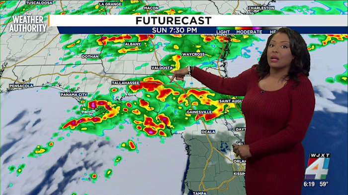
Rounds of light to moderate rain will continue through Sunday night into Monday morning.
Sunday Evening Forecast:
Temperatures will drop into the upper 50s and low 60s Sunday night with light winds from the northeast and cloudy skies. Light to moderate rain continues Sunday into the evening, with a heavy downpour possible closer to midnight. As of Sunday at 2 p.m., rain accumulation has ranged between half an inch to an inch.
FLOOD WATCHES AND WARNINGS: There is at least a 15% chance of flooding for low lying areas and communities with poor drainage through Monday morning in Southeast Georgia and Northeast Florida.
Where are the storms expected for the next 24 to 48 hours?
Monday Forecast:
Thunderstorms are likely during the early morning hours as the temperatures remain in the 60s with similar dew points. After sunrise, winds begin to shift to the west and northwest, with gusts ranging from 20 to 40 miles per hour at times.
Rain accumulation ranges from half an inch to an inch for Monday. Most rain is expected to dissipate by 5 p.m., but some light rain will linger until shortly after sunset. Temperatures will peak into the low 70s with mostly cloudy skies.
Looking Ahead:
Tuesday morning, clear sunny skies return with no chance for rain, and temperatures will peak into the low 70s. This pattern continues to Friday.
Copyright 2025 by WJXT News4JAX – All rights reserved.
Veteran journalist and Emmy Award winning anchor
Click here to take a moment and familiarize yourself with our Community Guidelines.
Recommended Videos
TV Listings
Email Newsletters
RSS Feeds
Contests and Rules
Contact Us
Careers at WJXT / WCWJ
Closed Captioning / Audio Description
WJXT Public File
WJXT EEO Report
WCWJ Public File
WCWJ EEO Report
Terms of Use
Privacy Policy
Do Not Sell My Info
FCC Applications
Cookie Preferences
If you need help with the Public File, call (904) 393-9801.
At WJXT, we are committed to informing and delighting our audience. In our commitment to covering our communities with innovation and excellence, we incorporate Artificial Intelligence (AI) technologies to enhance our news gathering, reporting, and presentation processes. Read our article to see how we are using Artificial Intelligence.
Copyright © 2025 News4JAX.com is managed by Graham Digital and published by Graham Media Group, a division of Graham Holdings.
LATEST NEWS
DEALS 4 JAX
Cold front arrives as rain continues, temperatures remain mild
DEALS 4 JAX
Florida lawmakers propose constitutional amendment to set county commission term limits, cement school board limits
Kingsland City Council considers request to close railroad crossing as residents oppose the move
Weather Impact Day continues as rain, storms start the day
‘Makes this process better and stronger’: Local lawmaker weighs in as bills to tighten ballot-initiative process advance
See these Insider Deals for home, beauty and sports enthusiasts
See these Insider Deals for home, beauty and sports enthusiasts
Hassle-free PDFs are just $24 away
WEATHER
ABOUT THE AUTHOR
Jenese Harris
A wet weekend has arrived
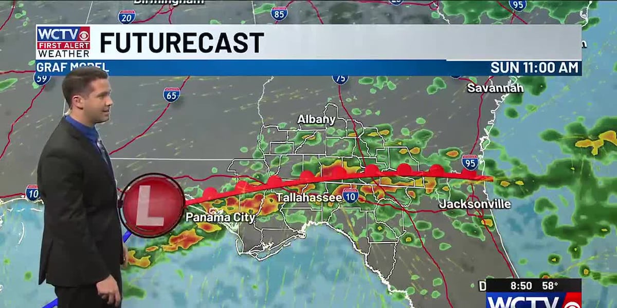
TALLAHASSEE, Fla. (WCTV) – The weather highway is busy today, as not one but two different systems will bring us rain this weekend. Scattered showers with one or two thunderstorms will arrive today. The Big Bend, especially south of I-10, is likely to receive more rain than South Georgia today thanks to a frontal boundary sitting to our north which is helping to stir up some energy.
Besides that, mostly cloudy skies with highs in the mid 70s and winds out of the south around 5 to 10mph. Mild and muggy this evening with more rain arriving overnight tonight as an area of low pressure and adjoining warm front moves across the Gulf Coast. This will set up more rain across our entire area on Sunday. A few thunderstorms are possible on Sunday as well. Rain chances for Saturday sit at 60-70%, with those increasing to 80-90% for Sunday.
Although a few showers are possible on Monday, most of the day will feature cooler and drier air returning. Tuesday and Wednesday look amazing with lows in the 40s, highs in the 70s, and sunny skies. An isolated shower or two is possible to close out the week as temperatures get close to 80 degrees.
To stay updated on all the latest forecasts and weather, follow WCTV First Alert Weather on Facebook and X (Twitter).
Click here to see all the latest weather headlines and here to view the First Alert Radar. Receive push alerts and watch the latest forecast anytime on the free WCTV First Alert Weather app. Click hereto download it now.
Interested in becoming a WCTV First Alert Weather Watcher? Click here to join the team!
Copyright 2025 WCTV. All rights reserved.
SPONSORED