Freeze Warning, Frost Advisory overnight in Georgia with snow possible in mountains
A brief cold pattern will turn mild and damp for the weekend. Here’s the latest from the FOX 5 Storm Team.
ATLANTA – A cold front sweeping through the Southeast is bringing gusty winds and a significant drop in temperatures.
Light snow is expected in higher elevations.
What we know:
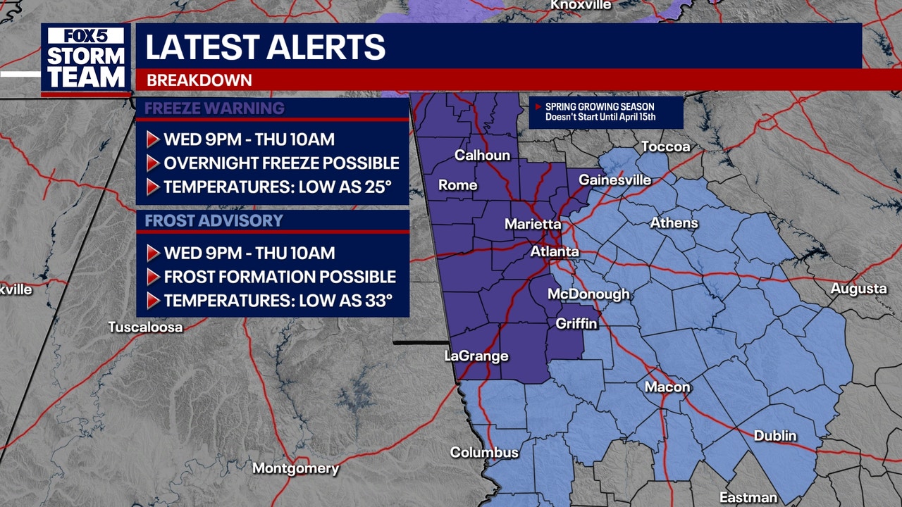
A Freeze Warning is in effect for Dade, Walker, Catoosa, Whitfield, Murray, Gordon, Chattooga, Floyd, Bartow, Cherokee, Forsyth, Polk, Paulding, Cobb, Fulton, Haralson, Carroll, Douglas, Heard, Coweta, Fayette, Spalding, Troup, Meriwether, and Pike counties through 10 a.m. on Thursday.
Temperatures are expected to dip into the upper 20s overnight in portions of north central, northwest, and west central Georgia.
What we know:
A Frost Advisory has been issued for Hall, Banks, Jackson, Madison, Gwinnett, Barrow, Clarke, Oconee, Oglethorpe, Wilkes, DeKalb, Rockdale, Walton, Newton, Morgan, Greene, Taliaferro, Clayton, Henry, Butts, Jasper, Putnam, Hancock, Warren, Upson, Lamar, Monroe, Jones, Baldwin, Washington, Glascock, Jefferson, Harris, Talbot, Taylor, Crawford, Bibb, Twiggs, Wilkinson, Johnson, Muscogee, Chattahoochee, Marion, Peach, Houston, Bleckley, Laurens, Stewart, and Webster counties through 10 a.m. on Thursday.
Temperatures in this area will hover around freezing and could lead to the formation of frost during the overnight hours.
What they’re saying:
“The winds are certainly not out of the picture at this point,” with gusts reaching over 30 miles per hour. A wind advisory remains in effect, making for a breezy and gusty evening. “We’re about 18 degrees cooler at this moment than we were 24 hours ago,” FOX 5 Storm Team Jonathan Stacey noted, attributing the chill to cloud cover and a steady westerly breeze.
As the night progresses, temperatures are expected to linger in the 40s, with a 10 to 20% chance of rain and possible spot showers. By Thursday morning, the wind chill will make it feel like 22 degrees in Atlanta and even colder in areas like Blairsville, where it could feel like 17 degrees.
The cold air is expected to bring light snow to higher elevations, including the plateau, southwest Virginia, and mountain foothills. A dusting to one inch of snow is possible across the plateau and Cumberland Mountains, extending into southwest Virginia. Northeast Tennessee and the mountain foothills may see a dusting to half an inch of snow, with localized higher amounts up to one inch in some ridges and mountains.
“Even light snow accumulation may result in localized slick conditions, especially on bridges and elevated surfaces,” cautioned weather officials, advising travelers in affected areas to exercise caution.
What’s next:
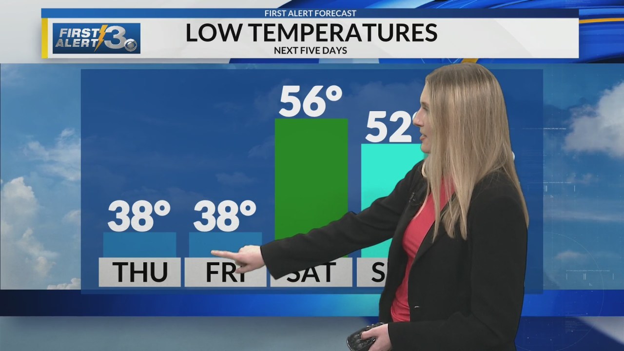
Looking ahead, Friday is expected to be dry but cloudy, with scattered showers anticipated on Saturday. By Sunday, a steady rain is forecasted, with heavy rainfall at times potentially bringing up to an inch of rain. “Scattered showers turn to rain by Sunday,” Stacey remarked.
The region can expect a return to sunshine and warmer temperatures next week.
The Source: This article is based on an original forecast by the FOX 5 Storm Team.
All the news you need to know, every day
By clicking Sign Up, I confirm
that I have read and agree
to the Privacy Policy
and Terms of Service.
A woman was fatally shot by Hiram police after allegedly stabbing her teen son to death on Sunday.
This material may not be published, broadcast, rewritten, or redistributed. ©2025 FOX Television Stations
Freeze Warning for North Georgia
Frost Advisory for metro Atlanta
Snow possible in North Georgia
Rain in Atlanta this weekend
Latest News
DAILY NEWSLETTER
New charges for man cited for animal cruelty in Coweta County
Mayor Dickens accuses former IG staff of spreading lies amidst corruption allegations
Atlanta Housing breaks ground on $64 Million Bowen Homes redevelopment
1 dead after car crashes into building in Norcross area, GSP says
‘Last warning’: Trump again threatens Hamas with ‘hell to pay’
Wednesday afternoon forecast
The Brief
News
Weather
Good Day Atlanta
Sports
Shows
About Us
Election
Money
Regional News
Cold Thursday morning behind yesterday’s storms
WRBL
by: Kaylee Barbee
Posted: Mar 5, 2025 / 06:08 PM EST
Updated: Mar 5, 2025 / 06:08 PM EST
COLUMBUS, Ga (WRBL)- Following the line of storms last night, windy conditions will remain through the next few days.
Tonight get ready for lows to drop into the mid-30s across the area. When you add in the winds, wind chill temperatures will sit in the 20s for everyone. Highs will struggle to get out of the 50s for your Thursday. Frost Advisories and Freeze Warnings are in affect until Thursday at 10AM ET.
The clouds will begin to return on Friday. Readings will trend warmer, rebounding back into the upper 60s.
Our next chance for rain will enter later Saturday evening. These scattered showers and storms will begin later Saturday and will continue through Monday morning. Because of the rain, lows will sit in the mid-50s through the weekend.
Lows cool back off into the 40s and we will have plenty of sunshine for the middle of next week.
Copyright 2025 Nexstar Media Inc. All rights reserved. This material may not be published, broadcast, rewritten, or redistributed.
Gardening is a beloved hobby for many. To celebrate the arrival of spring and the return to garden beds, try hanging up a new, funny garden sign.
Wayfair’s Big Outdoor Sale has arrived with up to 60% off outdoor furniture from patio seating sets to outdoor dining tables, umbrellas and more.
LEGO is capitalizing on Bluey’s success with a brand new collection of building sets.