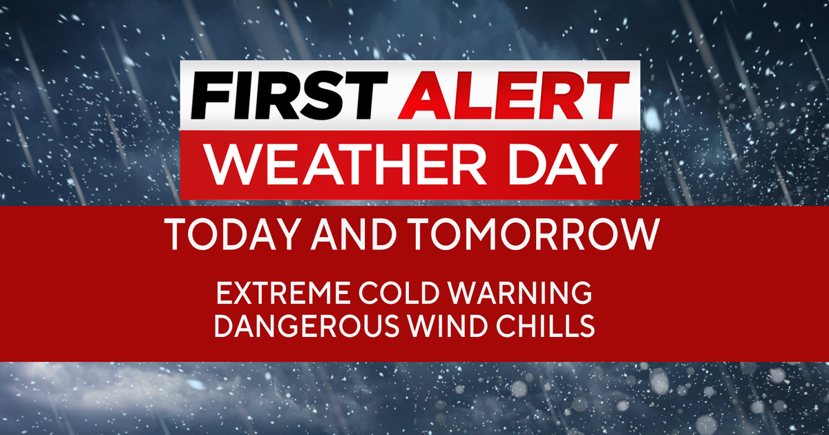
Dallas weather: Extreme Cold Warning in effect until Thursday, freezing rain possible
Dan Henry has the latest forecast.
DALLAS – Temperatures have fallen quickly as the coldest air of the season moves into North Texas.
An Extreme Cold Warning has been issued for North Texas from 9 p.m. Tuesday through 9 p.m. Thursday, with wind chills expected to drop temperatures at or below zero.
MORE WEATHER NEWS
Timeline:
Temperatures will be mild in the morning with temperatures in the 40s to near 50s.
We will see some light rain and drizzle as we get lift ahead of the Arctic front.
Once the front moves through, it will get cold fast.
Areas west of I-35W will see the temperatures drop before noon.
That will be at the time that we expect to see light right, meaning there could be some ice.
In the DFW area, Fort Worth should drop below freezing around 5 to 6 p.m. In Dallas, it may take until 6 tp 7 p.m.
There is about 2 to 3 hours after we drop below freezing that light rain or drizzle will be falling and could produce some icy spots on bridges and overpasses.
If you are driving tonight, please be careful.
All precipitation should dry up as we approach midnight, but 30 mile per hour winds and temperatures will fall into the 20s.
Be sure to drip your pipes on Tuesday night.
Timeline:
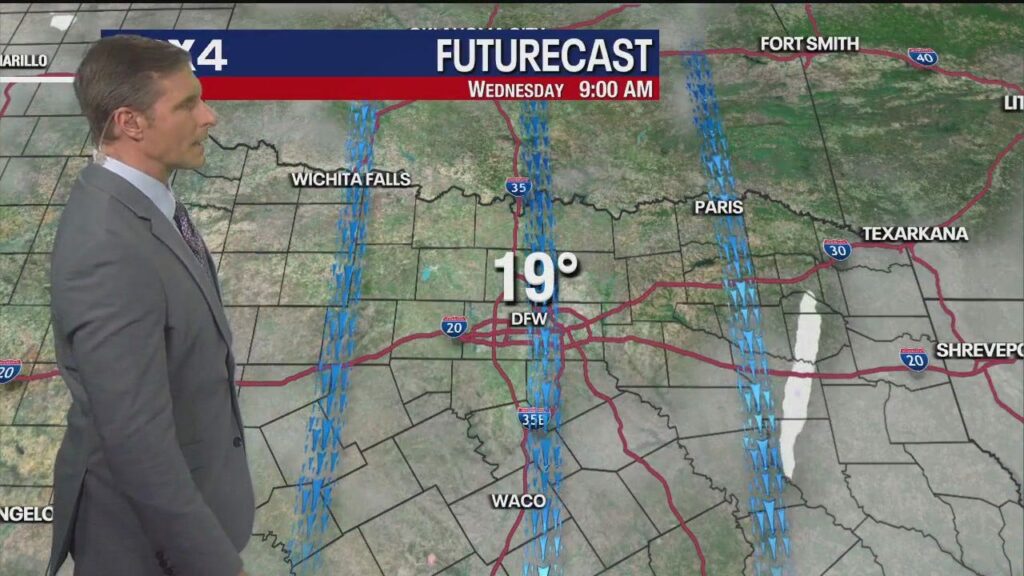
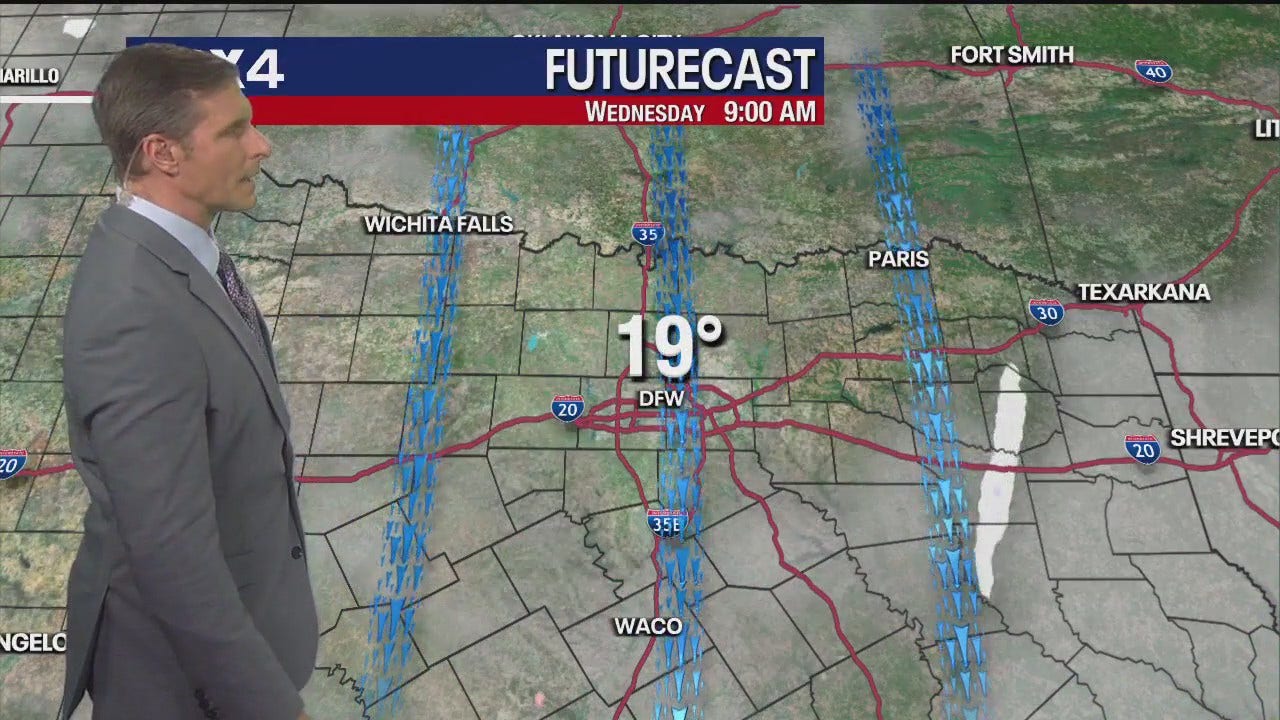
Temperatures will be in the teens by sunrise in DFW, with wind chills near zero in the Metroplex and below zero to the north and west.
Clouds will slowly decrease Wednesday, which should allow us to warm up a few degrees into the upper 20s, but we will be below freezing all day.
Wind chills will be in the teens into the afternoon.
Timeline:
Skies will clear at night and we will see the coldest temperatures of this Arctic blast on Thursday morning.
The current record for lowest temperature on Feb. 20 at DFW is 19 degrees. That record will be broken by a few degrees.
Wind chills will be below zero that day as well.
We could see lake effect snow on the south side of area lakes with the lighter winds and extremely cold temps.
Thursday will be partly to mostly sunny with temperatures briefly getting above freezing for an hour of two in the afternoon to evening.
Clouds will rapidly roll in on Friday ahead of a system approaching from the west that will keep us from getting much above freezing.
The system on Friday night to early Saturday morning will have some patchy rain and it is possible that we could see a few icy spots.
Keep an eye on the FOX 4 WAPP for the latest updates on the forecast, which will be fine tuned as we get closer.
An Extreme Cold Warning is issued when temperatures or wind chill values are forecasted reach dangerously cold levels for an extended period of time.
If you are in an area with an Extreme Cold Warning, avoid going outside. If you have to go outside, dress in layers, cover exposed skin, and make sure at least one other person knows your whereabouts.
The Source: Information in this article comes from the FOX 4 Weather team and the National Weather Service.
All the news you need to know, every day
By clicking Sign Up, I confirm
that I have read and agree
to the Privacy Policy
and Terms of Service.
This material may not be published, broadcast, rewritten, or redistributed. ©2025 FOX Television Stations
Tuesday Forecast: Mild start, ice may form late
Live Radar: North Texas
Wednesday Forecast: Wind chills near or below zero
Thursday Forecast: Record-breaking cold
7-Day Forecast
Extreme Cold Warning
DAILY NEWSLETTER
Trending Now
Dallas Weather: Feb. 18 overnight forecast
The Brief
Former Texas H.S. coach sentenced to 30 years for sexually abusing 15-year-old student
Woman arrested after police say deadly Fort Worth crash was intentional
Texas Measles outbreak 2025: 58 cases across 5 counties in 3 weeks
Farmersville man with meth caught trying to steal ATM sentenced to 47 years
How to properly drip your faucets
News
Weather
Sports
Good Day
Latest Episodes
About Us
Regional News
Snow flurries fall around North Texas as extreme cold warning continues
Watch CBS News
By Scott Padgett, Julia Falcon
Updated on: February 19, 2025 / 6:56 AM CST / CBS Texas
A very cold Wednesday is ahead for North Texas, with several weather alerts in effect. CBS News Texas meteorologists have issued First Alert Weather Days for today and Thursday.
An extreme cold warning is in effect until 9 a.m. Thursday. It includes all of North Texas.
Wind chills on Wednesday could drop “feels-like” temperatures to -12 degrees in some parts of North Texas. Winds could gust up to 30 mph.
Just after 4 a.m., the “feels-like” temperature at Dallas-Fort Worth International Airport fell to zero degrees. The coldest weather reported was in Bonham, with “feels-like” temperatures at -9 degrees.
First Alert Weather Days remain in effect today and Thursday due to the extreme cold warning and dangerous wind chills.
Temperatures will only warm up to the teens and low 20s. Dress up in layers on Wednesday, limit time spent outdoors and protect exposed skin.
Between 5 a.m. Tuesday and 5 a.m. Wednesday, temperatures across North Texas dropped nearly 40 degrees.
The dangerous cold weather continues on Thursday, with temperatures in the teens but feeling like single digits.
Record low temperatures are possible Thursday morning with a forecast low of 14 degrees. The record low temperature on that date is 19 degrees, set back in 1939. But Texas will be Texas and temperatures will be back into the 70s for highs starting next week.
At around 3 a.m., snow flurries were seen falling in West Fort Worth, Wise County, Johnson County and parts of Parker County. Snow accumulated on grass, but isn’t expected to cause any problems on the roads.
Dallas was dry for the most part, but CBS News Texas crews reported seeing large snow flakes in far North Dallas.
The snow falling across North Texas is dry snow, so it won’t stick on the roads.
Some of the snow is called lake effect snow, which happens when cold air moves over warm water, picking up the moisture and developing into snow.
The CBS News Texas First Alert Radar showed a band of snow developing over Lake Lewisville, dropping southeast. There were also bands of snow over Benbrook Lake and Grapevine Lake.
Chief Meteorologist Scott Padgett joined CBS 11 in September 2013.
© 2025 CBS Broadcasting Inc. All Rights Reserved.
©2025 CBS Broadcasting Inc. All Rights Reserved.
Snow falling in Fort Worth, western parts of North Texas
What is lake effect snow?
More from CBS News
More from CBS News
First Alert Weather Day: Winter weather alerts and warnings in effect across DFW
Sunday cold snap in North Texas ahead of dangerous arctic air midweek
Here’s how to stay updated on school closings in North Texas
Freezing temps and dangerous wind chills ahead for DFW
An arctic blast is heading to the Austin area. Here’s what you need to know.
An arctic blast is expected to arrive this week with below-freezing temperatures hitting the Austin area Tuesday night and sticking around through Thursday.
The National Weather Service has issued a cold weather advisory for the Austin area from midnight until noon Wednesday and an extreme cold warning Wednesday night through Thursday morning.
The NWS has also issued a wind advisory from Tuesday night through Wednesday at noon with gusts possibly reaching 40 mph in some parts of Central Texas. High-speed winds could make it difficult to travel and knock down tree limbs. The winds could also cause power outages.
The agency expects the overnight windchill – which will bring the coldest weather of the season – could make temperatures feel like 10 degrees or lower, putting people and pets outside at risk of hypothermia. Without protection, plants and pipes could also suffer from the extreme cold.
“There will be widespread freezing across the entire state with temperatures down to near zero degrees,” Gov. Greg Abbott said at a news conference Monday. “People need to be very cautious over the coming days as temperatures plummet, so make sure that you take care of yourself.”
The weather service said there’s a low chance of precipitation in the Austin area Tuesday night and Friday. Mack Morris, a meteorologist for the NWS, said, however, that the area likely won’t see a wintery mix of snow, sleet and freezing rain like it did last month.
“It’s probably going to be fairly dry,” he said. “This front compared to the last one, there’s not nearly as much moisture to work with.”
If there is precipitation, he said, it’ll probably be liquid and not a cause for concern.
The cold weather is expected through the weekend.
Morris recommends people wrap their pipes and drip faucets when temperatures dip below freezing this week.
“Because of our exposed pipes and because we don’t drain our pipes like they do up north, there’s still could be water in them,” he said. “If that water freezes, it hardens and it expands. … It could make [pipes] crack, which is not good.”
Running water is less likely to freeze than still water, so plumbers recommend dripping both hot and cold water overnight as a precaution when it’s freezing outside. That goes for both houses and apartments.
The Electric Reliability Council of Texas, which manages the state’s electric grid, issued a weather watch for Wednesday through Friday due to the forecast. The watch means there could be a higher demand for electricity than what is available.
ERCOT said it expects grid conditions will be normal during this time and that it would be monitoring weather conditions. The agency recommends residents sign up for notifications through the Texas Advisory and Notification System (TXANS) to stay informed.
Austin’s Homeless Strategy Office said the city will open cold-weather shelters on Tuesday, Wednesday and Thursday nights. People can register to stay at the shelters from 6-8 p.m. at One Texas Center on Barton Springs Road. Capital Metro bus fare to the center will be free.
Under updated rules, the city now opens overnight shelters when the forecast is 35 degrees or below. More information on shelters can be found here.
Austin’s Parks and Recreation facilities and city libraries will also serve as warming centers during the day. The city recommends checking hours of operation before arriving.
Southside Community Center in San Marcos, the only overnight warming center in Hays County, said it would open Tuesday at 7 p.m. and provide updates on its Facebook page about operations later in the week.
Follow the latest tweets from the NWS below.
Today’s Top News: All in One Place
Get the most important Austin stories delivered in an easy-to-read format to connect with your community. Subscribe to our free newsletter today!