![]()
Massive March storm with hurricane-force winds is knocking out power and threatening a blizzard, fires and tornadoes
![]()
A powerful and sprawling storm is moving across the country and spawning severe thunderstorms with hurricane-force wind gusts that are knocking out power and causing damage Tuesday morning.
Tens of millions of people across the central and southern US are at risk Tuesday of severe thunderstorms, tornadoes and fire weather on the storm’s warm side and blizzard conditions on its cold side.
Here’s the latest:
• Widespread power outages: Severe thunderstorms rocked the Dallas-Fort Worth Metroplex around sunrise with wind gusts up to 78 mph. An 87 mph wind gust blew through southern Oklahoma. Over 400,000 homes and business lost power in Texas and Oklahoma early Tuesday, according to PowerOutage.us.
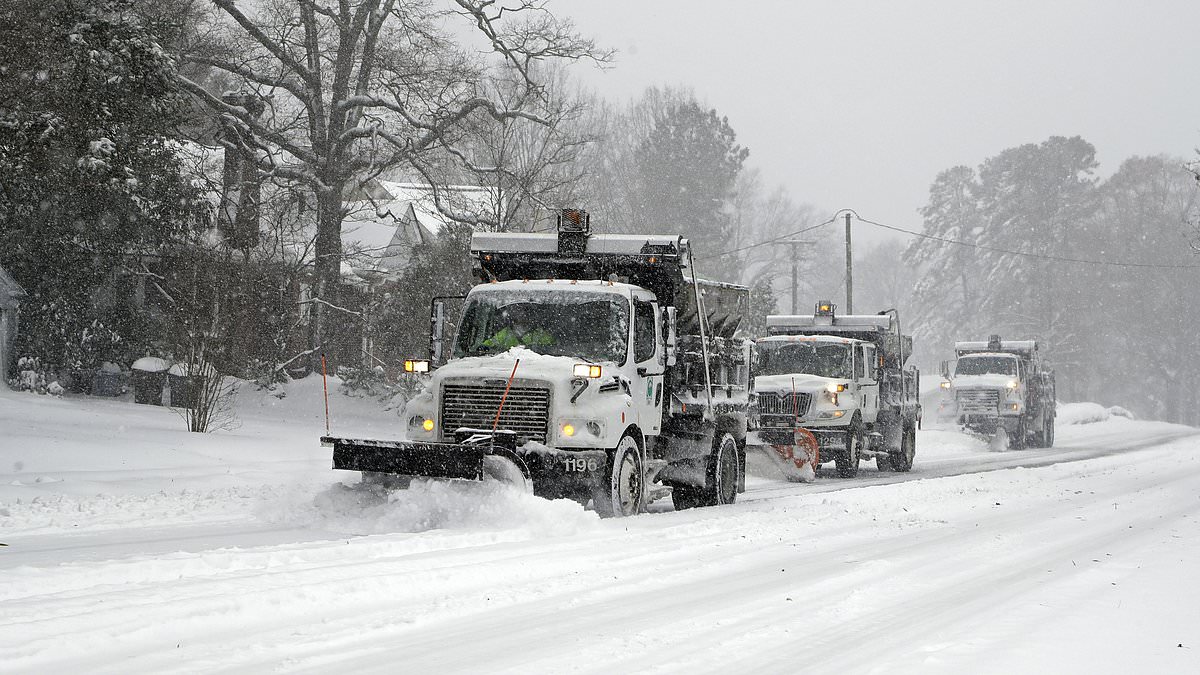
• The storm is massive: Impacts in the central US stretched from border to border Tuesday morning, with severe thunderstorms raging in the South, snow and ice falling in the Midwest and blizzard warnings in parts of the Plains.
• Blizzard conditions possible: Blizzard warnings were posted Tuesday in parts of six states and were active in Colorado, Kansas and Nebraska. “Whiteout conditions are expected and will make travel treacherous and potentially life-threatening,” the National Weather Service in North Platte, Nebraska, warned. Additional blizzard warnings will go into effect Tuesday evening from the Kansas City, Missouri, area to just south of Minneapolis.
• Extreme fire risk: A level 3 of 3 extremely critical fire weather risk is in effect Tuesday for a large portion of Texas — including Austin and San Antonio — and part of southeastern New Mexico, according to the Storm Prediction Center. Powerful winds and very dry soil in the area are primed for “very rapid wildfire spread/extreme fire behavior,” warned the SPC.
• Mardi Gras threatened: The powerful storm comes amid Mardi Gras celebrations across the South. In New Orleans, officials rushed to reschedule Mardi Gras day events and shorten parade routes to avoid the potentially destructive weather. A high wind warning is in effect for the city from 9 a.m. to 9 p.m. local time on Tuesday as winds are expected to be sustained at 20 to 30 mph with gusts over 50 mph possible. The city is also under a level 3 of 5 risk of severe thunderstorms during the afternoon and evening. New Orleans Police Superintendent Anne Kirkpatrick warned she will pull the plug on festivities entirely if the weather worsens: “I won’t do it lightly, but I will do it.”
• Dust storm: A massive dust storm swept over swaths of New Mexico, Texas and Mexico on Monday, bringing violent winds and cloaking roadways in near-zero visibility. Officially called a haboob, the fast-moving wall of dust and debris prompted New Mexico officials to close parts of multiple interstates after the sudden wall of dust appeared to force some vehicles off the road. Video taken by a passing truck driver near the city of Deming, New Mexico, showed emergency vehicles positioned around a tangle of stopped vehicles, including tractor trailers and an RV-towing pickup truck with debris scattered across the highway.
• First test of depleted NOAA: The dangerous storm is the first major weather event after staffing at the National Oceanic and Atmospheric Administration and its National Weather Service was slashed by the Trump administration –– cuts scientists say will have dangerous consequences for the safety of the American public. Around 800 employees were laid off across NOAA last week.
The storm will increase in intensity as it moves east Tuesday, threatening the Lower Mississippi River Valley with strong tornadoes, powerful winds, hail and heavy rainfall. These storms will last into the night as they track over the Southeast, with tornadoes still possible after dark. Nighttime tornadoes are nearly twice as likely to be deadly as those occurring during the day, a 2022 study found.
Louisiana, Mississippi and parts of Arkansas, Alabama and the Florida Panhandle will likely experience the worst severe weather Tuesday, especially from the afternoon onward. Some strong tornadoes, wind gusts over 74 mph and large hail are possible for cities like New Orleans and Shreveport, Louisiana, and Jackson, Mississippi. These storms will likely bring heavy rainfall totaling as much as 3 inches.
Other parts of the Mississippi Valley and Southeast will see a slightly less intense threat for severe storms, but tornadoes, gusty winds and hail are possible in Memphis, Tennessee, Birmingham, Alabama, and Atlanta.
The wide-reaching storm will hit the East Coast Wednesday.
More than 29 million people from Florida to Pennsylvania – including Washington, DC, and Baltimore – are under a level 2 of 5 risk of severe thunderstorms, according to the SPC. Damaging wind gusts and a few tornadoes are possible within these storms.
About 8 million people in the Carolinas and southern Virginia are under a level 3 of 5 risk of severe thunderstorms. Storms in this area could unleash damaging wind gusts in excess of 75 mph and tornadoes.
Heavy rain and strong winds will impact much of the Northeast while the storm creates blizzard conditions in parts of the Midwest.
Wind gusts of 40 mph or more could occur over much of the eastern half of the US throughout the day, even outside of any wet or wintry weather.
These winds could wreak havoc on air travel, especially with hubs in Chicago and the New York City area impacted. More than a dozen states could also face power outages.
Much of the storm’s precipitation will come to an end Thursday, but gusty winds will persist in its wake.
CNN’s Gene Norman contributed to this report.
© 2025 Cable News Network. A Warner Bros. Discovery Company. All Rights Reserved.
CNN Sans ™ & © 2016 Cable News Network.
Hazardous weather won’t let up soon
Up next
Most read
MORE FROM CNN
NEWS & BUZZ
BREAKING NEWS
Life-threatening weather warnings issued across large swath of US set for tornadoes and blizzards TODAY
By STACY LIBERATORE FOR DAILYMAIL.COM
PUBLISHED: 13:41 GMT, 4 March 2025 | UPDATED: 14:02 GMT, 4 March 2025
1
View
comments
More than a dozen US states are bracing for severe weather on Tuesday, bringing blizzards to the north and tornadoes to the south.
The National Weather Service (NWS) shows a significant winter storm, named ‘Lola,’ is making its way across parts of the Plains and Midwest that could see up to 18 inches.
‘Whiteout conditions are expected and will make travel treacherous and potentially life-threatening. Plan on slippery road conditions,’ the NWS shared in a statement.
‘The hazardous conditions could impact the Tuesday morning and evening commutes. Very strong winds could cause extensive tree damage.’
The National Weather Service has issued winter weather alerts from the Rockies to the Central Plains and upper Midwest.
That includes blizzard warnings for portions of Kansas City, Omaha, Nebraska, Des Moines, Iowa, and Rochester, Minnesota.
Parts of Texas, Arkansas and Oklahoma are under a tornado watch as a potent thunderstorm is set to hit Tuesday morning.
Up to 75-mile-per-hour winds are expected across the Dallas-Fort Worth area, including 34 surrounding counties, which is under the advisory until 11am CT. Eastern Oklahoma and western Arkansas have the same warning.
Meteorologists warned these regions could see ‘a few tornadoes,’ damaging winds and hail up to 1.5 inches.
The National Weather Service (NWS) shows a significant winter storm , named ‘Lola,’ is making its way across parts of the Plains and Midwest that could see up to 18 inches
Storm Lola is not expected to produce major snowfall totals, but meteorologists at The Weather Channel warned that the blizzard would create near-impossible travel conditions.
That is due to gusts up to 70 miles per hour ripping through the Central Plains starting Tuesday morning, which will move toward the upper Midwest this evening.
‘Travel conditions will likely be extremely dangerous where the snow and strong winds overlap,’ The Weather Channel warned.
‘Some broken tree limbs and power outages are possible, as well.’
On Tuesday, the swath of snow will expand and shift from northeastern Colorado to South Dakota and central and western Minnesota.
Lola is likely to linger in the upper Midwest, including the Great Lakes, Ohio River Valley and Appalachians, until Wednesday evening.
Minneapolis, Chicago, Cleveland and Pittsburgh may also experience snow conditions.
Meteorologists predict less than six inches of snow in the Central Plains and upper Midwest, while central parts of Wyoming could see between 12 to 18 inches.
The National Weather Service has issued winter weather alerts from the Rockies to the Central Plains and upper Midwest
Parts of Texas , Arkansas and Oklahoma are under a tornado watch as a potent thunderstorm is set to hit Tuesday morning
Blizzard conditions are also expected in Arkansas, Colorado, Kansas and Nebraska before the system moves east and takes aim at the upper Midwest.
But temperatures should not hit freezing during the winter storm.
At the same time, three states to the south are bracing for severe thunderstorms and possible tornadoes.
A Tornado Watch was issued for more than 10 million people in parts of Texas, Oklahoma and Arkansas on Tuesday morning.
The alert is for Dallas, Fort Worth, McKinney and Waco in Texas, where residents will see strong winds and ping-pong ball-sized hail.
Up to 75-mile-per-hour winds are expected across the Dallas-Fort Worth area, including 34 surrounding counties, which is under the advisory until 11am CT. Eastern Oklahoma and western Arkansas have the same warning (stock)
Intense lighting was observed in Abilene early Tuesday. The Federal Aviation Administration (FAA) has ordered a ground stop at DFW International Airport until at least 6:30 CT.
And Oncor shows more than 275,00 people were without power in the Dallas-Fort Worth area after 6am CT.
Structural damage has been reported in Allen, Oklahoma due to high winds, while McAlester is set to see hail nearly the size of golf balls.
Local KocoNews 5 reported that a possible tornado hit Ada at 7:20am CT, causing significant damage to an elementary school.
Parts of western Arkansas are set to see a storm roll in between 7am and 8am CT.
Western parts of Central Arkansas could have storms by 9am. The Little Rock Metro should have storms from 10am to 2pm. Storms should be out of the state around 3pm.
Comments are subject to our House rules and Terms
Leave a comment so your voice will be heard first.
Published by Associated Newspapers Ltd
Part of the Daily Mail, The Mail on Sunday & Metro Media Group
Share or comment on this article: Life-threatening weather warnings issued across large swath of US set for tornadoes and blizzards TODAY
Comments (1)
DON’T MISS
TECH NEWS & REVIEWS
Read More
Dozens of neighborhoods are evacuated as 175 wildfires rip through North and South Carolina
This site can’t be reached
weather.com’s server IP address could not be found.
Try: