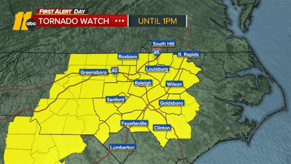
Tornado watch issued for Triangle counties with heavy rain, high winds possible
Severe weather risk today.
RALEIGH, N.C. (WTVD) — The Triangle may get some severe weather that could feature isolated tornadoes and hail. A cold front will bring strong winds, periods of heavy rain, and a chance for some strong thunderstorms, some of which could be severe this afternoon.
Tornado Watch: There is a tornado watch for all counties in the Triangle including Orange, Durham, Wake, Johnston, Cumberland.
WATCH: Preparations continue as strong storm system draws closer
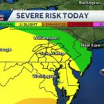
There’s a level 3 of 5 severe risk across central North Carolina. The current window of severe weather in central North Carolina is between 10 a.m. to 3 p.m.
Damaging wind gusts are the main threat. Tornadoes and hail are secondary threats. Even outside of severe storms, wind gusts of 40-50mph will be possible. Rain totals will be around 1.5″ or less. Due to the wind gusts, power outages are possible with this storm.
Scattered showers will developed shortly after sunrise. The intense line of showers and thunderstorms will move into areas west of the Triangle around 10 a.m. and into the Triangle around 11 a.m. The line will be east of the Triangle by 1 p.m. and east of I-95 by 3 p.m. Highs will be in the 60s with lows in the 40s.
Cooler and drier air will settle in Wednesday night behind the front, with lows in the 40s.
SEE ALSO | Tornado watch vs warning: Here’s the difference and what they mean during severe weather
First Alert Forecast Timeline
Related Topics
Top Stories
Two Clayton police officers rescue 11-year-old girl from pond
Inflation, tariff thoughts on top of mind for Triangle shoppers
These 21 intersections are most ‘dangerous’ in Raleigh, NCDOT says
IRS drafting plans to cut as much as half of its workforce: sources
Alston Yards project aims to reshape area of west Cary
Download the ABC11 App get Breaking and Weather Alerts on Your Phone
Suspect in Kabul airport has been caught, is heading to US, Trump says
Democratic Rep. Al Green removed from Trump address
In Democratic response, Slotkin hits Trump on food prices
FIRST ALERT: Damaging wind gusts the main threat with our morning cold front
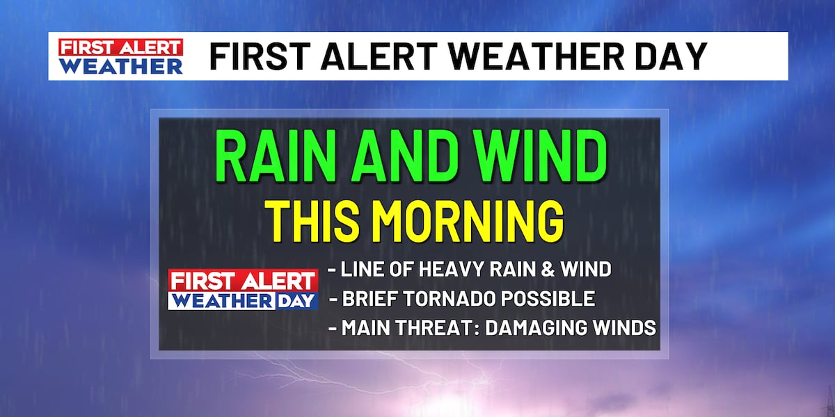
COLUMBIA, S.C. (WIS) – Damaging wind gusts and a brief tornado can’t be ruled out this morning as our cold front moves through.
First Alert Headlines.
Read more
First Alert Summary
Good morning! Today remains a First Alert Weather Day for heavy rain and strong winds with a cold front passing through the Carolinas. Waking up this morning, the Eastern Midlands remain in a Level 3 of 5 ‘Enhanced’ risk of severe weather. As these showers and storms move through, damaging wind gusts up to 75 MPH and a brief tornado are the main threats. The best chance at a severe storm will occur along I-95.
Starting around 7 AM, this line of thunderstorms will move into our western counties. By 9 AM, this line will be across the heart of the Midlands, with showers and storms shifting to the I-95 corridor by 11 AM. As we head throughout the morning, this cold front will gain strength, which is why the greatest threat for severe weather is along I-95.
Around Noon, our severe weather threat will come to a close as our cold front moves offshore. This afternoon, skies will partially clear behind our cold front, revealing some broken sunshine. A Wind Advisory will remain in effect until 7 PM for wind gusts up to 45 MPH. Post-frontal sunshine will help high temperatures reach the low and mid-70s this afternoon.
We’ll dry out behind today’s cold front and winds will remain breezy, which means fire danger will remain an elevated concern. Temperatures will also drop quickly, with highs only in the upper-50s Thursday afternoon. By Friday morning, we’ll once again wake up with temperatures in the 30s.
First Alert Forecast
Today (First Alert Weather Day): Widespread showers and storms before lunchtime. Damaging wind gusts are possible with a few of these storms. Chance of rain 100%. Skies partially clear this afternoon with highs in the low and mid-70s.
Tonight: Partial clearing of thick cloud cover overnight. Windy, with lows around 40 degrees.
Thursday: Lots of sunshine. Windy and cooler, with highs in the upper-50s.
Friday: Partly cloudy skies. Highs in the mid and upper-60s.
Saturday: Partly to mostly cloudy. A slight chance of rain late in the day. Highs in the mid-70s.
Sunday: Scattered showers in the morning with partial clearing for the afternoon. Chance of rain 40%. Highs in the upper-50s.
Feel more informed, prepared, and connected with WIS. For more free content like this, subscribe to our email newsletter, and download our apps. Have feedback that can help us improve? Click here.
Copyright 2024 WIS. All rights reserved.
Most Read
Latest News
Severe storms possible Wednesday morning with strong winds the primary concern
Midlands school districts announce closures, delays ahead of severe weather
Inmate found dead in cell at Broad River Correctional Institution
Pentagon changes name of Georgia Army base back to Fort Benning, dumping Fort Moore
26-year-old woman dies by suicide after struggling with extreme pregnancy sickness, reports say
Man accused of purchasing hotel rooms with South Carolina Education Lottery credit card
GOP lawmakers revive ‘medical freedom’ bill in SC, but some doctors are worried
Gamecocks head football coach Shane Beamer speaks before House committee about NIL impacts
Midlands school districts announce closures, delays ahead of severe weather
Damaging wind gusts the main threat with our morning cold front
Download the WIS First Alert Weather app
Severe storms possible Wednesday morning with strong winds the primary concern
DAY 4: State officials say Carolina Forest wildfire ‘believed to be human-caused’
First Alert Weather March 4, 2025
Crews battle 474-acre wildfire in Oconee County
Q&A: What are the threats and timing from Wednesday’s severe thunderstorms?
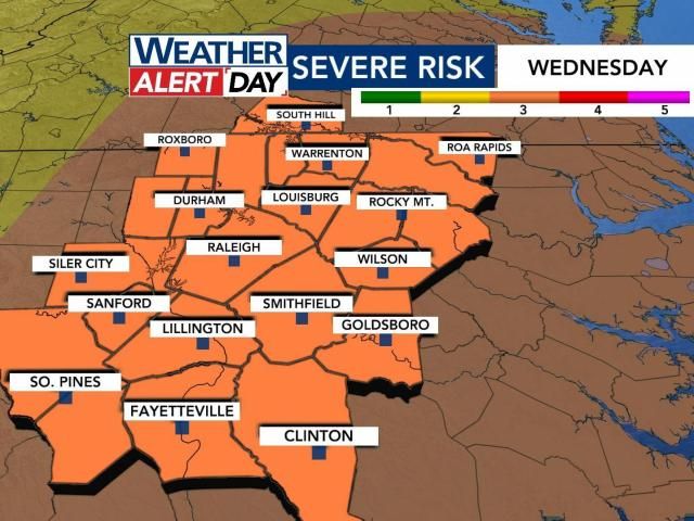
Much of central North Carolina, including our area, is under a Level 3 (out of 5) risk for severe storms Wednesday. A Level 3 risk is uncommon for our area and indicates storms may be more numerous, persistent and widespread.
“For our area it doesn’t happen very often, but it does mean that we have to take this very seriously,” WRAL meteorologist Aimee Wilmoth said.
Storms won’t roll in until after 8 a.m. on Wednesday, but winds could start to pick up in the morning.
That’s why a Wind Advisory is in effect for much of North Carolina Wednesday.
NOAA’s Storm Prediction Center has placed our areas under a Level 3 risk out of 5 for severe thunderstorms Wednesday.
The National Weather Service in Raleigh says the last time we had a Level 3 risk on the Day 2 outlook was Aug. 7, 2023. WRAL reported 80,000 without power in the Triangle from that day.
Granted, we hit 90 degrees that day, and there was a lot more lightning with that line of storms. It’s unlikely we see 80,000 without power this time around, but we discuss power outages below.
Tune in to WRAL News+ for the latest info on timing & impacts of Wednesday’s storms
This has increased since Monday. A Level 3 indicates that ‘numerous’ reports of severe weather damage will happen.
Wind damage from straight-line gusts is of growing concern as of this latest outlook.
This will be a line/a broken line of showers and storms that moves from west to east between about 9 a.m. and 2 p.m.
Areas west of Raleigh can expect the worst of the weather to start by 10 a.m. This will move east through 2 p.m., and it will be out of our area for the evening commute.
A few isolated storms will be possible during the evening, but the “main event” will be late morning/early afternoon.
We’ll stay windy at times into Thursday, as our area of low pressure swirls to the north.
FutureCast relies on short-term, high-resolution data. We’ve got a first look at that Monday morning, and it updates every six hours.
I’ve split it up into four panels below to give you an estimate of the timing.
In a case like this, damaging wind gusts are the main thing we’ll track. The most extreme gusts could reach/exceed 70 mph, which is why our threat level is higher-than-usual. Sometimes, these lines of storms can have rotation on their northern edges, so the tornado threat is not zero. (It is not comparable to April 16, 2011. We’ve had some questions about that.)
We are not expecting widespread, large hail or flooding at this time.
Given the potential for damaging wind gusts, I would say that power outages are of potential concern. We saw that happen a few Sundays ago when a similar line pushed through central North Carolina and knocked out power to thousands.
NOAA’s Storm Prediction Center indicates that scattered gusts of 70-75 mph will be possible throughout the Carolinas.
A watch means that something is possible/conditions are favorable within the next few hours. This is when you prepare.
A warning means that something is imminent or currently happening. This is when you take action.
A lot of times, we’ll use the acronym SLIM to diagnose severe weather possibilities.
This acronym stands for:
There is plenty of wind shear in the atmosphere to allow for strong wind gusts. The instability is questionable, which could be a limiting factor in our severe potential.
You’re rooting for an earlier start time. That would prevent the atmosphere from warming and becoming unstable.
This is always a challenging question to answer. If you plan on flying to Houston, Chicago, St. Louis, Kansas City, Memphis, etc. on Tuesday, you may very well have some delays. In terms of our weather, I could see there being at least brief delays at RDU as the line passes through, but I cannot speak to cancellations.
This is again one of those questions that I cannot entirely answer, since we’re not involved in those decisions. I will say that the worst of the weather looks like it would come in after bus stop time.
I have seen school systems amend schedules or after-school programs in the past when there’s the potential for severe thunderstorms.
If a tornado warning is issued, we will be live in continuous coverage on all platforms.
Local news & alerts
Copyright 2025 by Capitol Broadcasting Company. All rights reserved. This material may not be published, broadcast, rewritten or redistributed.