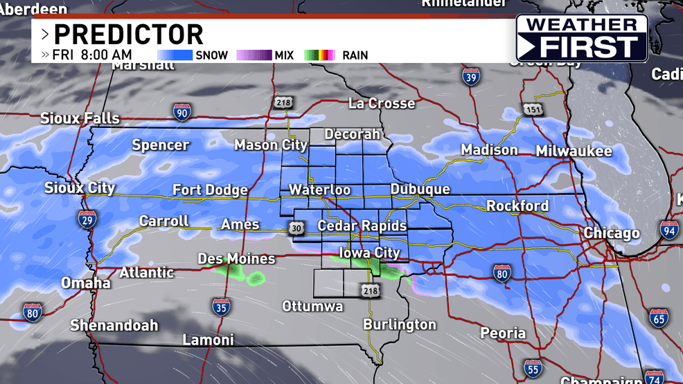
Another round of snow will lead to slick Friday morning commute in eastern Iowa
33
Snow will create slick and slushy streets through the first half of Friday. Rain will begin to mix in during the afternoon. Take it slow!
by Rebecca Kopelman & Cayson Frerichs
TOPICS:
CEDAR RAPIDS, Iowa (Iowa’s News Now) — We’ll have a brief breather Thursday before more wintry weather arrives in eastern Iowa.
Clouds will build in Thursday and rain will move in from west to east around 11 p.m. There will be a transition to wet snow overnight into Friday morning.
Snow will likely be falling during the morning drive and lead to slushy/slick streets. Higher impacts will be in elevated areas, like bridges and overpasses, as temperatures hover around the freezing mark.
Temperatures will creep just above freezing in the afternoon and lead to a change over to rain or a rain/snow mix.
Warmer surface temperatures may lead to more of a rain/snow mix to the south of I-80, which would limit snow totals in that area.
The highest chances for accumulation will be north of I-80 to the Highway 20 corridor with totals up to 3″especially in western counties.
Snow will wind down between 2 p.m. to 5 p.m. from northwest to southeast. Skies will clear and, with sunny, mild weather ahead, snow will start to melt over the weekend.
CHECK ROAD CONDITIONS HERE // CHECK DELAYS & CLOSURES HERE
Review of the March 4-5, 2025 Blizzard and High Wind Event
Sioux Falls, SD
Weather Forecast Office
Overview
A major winter storm resulted in moderate to major impacts much of the region from the morning of Tuesday March 4th to the afternoon of Wednesday March 5th, 2025. Light rain or drizzle, as well as isolated thunderstorms, transitioned to light to moderate snow during day through early evening of Tuesday March 4th 2025. Snow coupled with very strong winds gusting 40 to 65 mph, producing blizzard conditions along and east of a Minneota, MN to Orange City, IA to Elk Point, SD line on Tuesday night March 4th through Wednesday afternoon March 5th.
The greatest impacts occurred where the heaviest snow and strongest winds coincided across northwest Iowa, northeast Nebraska, and portions of southwest Minnesota. Interstate 90 was closed east of Luverne, MN and most roads in southwest Minnesota, northeast Nebraska, and northwest Iowa were either closed, impassable, or with travel not advised by the morning of Wednesday March 5th.
Wind:
Wind gusts of 40-60 mph were common during the evening on March 4th, continuing overnight, and gradually weakening west to east on March 5th.
POPULAR PAGES
Past Weather Events
Regional Weather Roundup
Daily Temp/Precip
Hazardous Weather
Local Climate Archives
Climate Graphs and Data
NEED TO KNOW
Storm Spotter Training
Text Products
Education
En Español
About Us
SEASONAL
EvapoTranspiration
Fire Weather
Grassland Fire Danger
Flooding (River)
Summer Weather
Travel Forecasts
Winter Weather
Winter Preparedness
Forecast Snowfall Graphic
Winter Temp Climatology
CITY FORECASTS
Chamberlain, SD
Brookings, SD
Huron, SD
Mitchell, SD
Sioux Falls, SD
Vermillion, SD
Yankton, SD
CITY FORECASTS
Marshall, MN
Pipestone, MN
Windom, MN
Worthington, MN
Sioux City, IA
Spencer, IA
Storm Lake, IA
US Dept of Commerce
National Oceanic and Atmospheric Administration
National Weather Service
Sioux Falls, SD
26 Weather Lane
Sioux Falls, SD 57104-0198
605-330-4247
Comments? Questions? Please Contact Us.
|
A major winter storm resulted in moderate to major impacts much of the region from the morning of Tuesday March 4th to the afternoon of Wednesday March 5th, 2025. Light rain or drizzle, as well as isolated thunderstorms, transitioned to light to moderate snow during day through early evening of Tuesday March 4th 2025. Snow coupled with very strong winds gusting 40 to 65 mph, producing blizzard conditions along and east of a Minneota, MN to Orange City, IA to Elk Point, SD line on Tuesday night March 4th through Wednesday afternoon March 5th. The greatest impacts occurred where the heaviest snow and strongest winds coincided across northwest Iowa, northeast Nebraska, and portions of southwest Minnesota. Interstate 90 was closed east of Luverne, MN and most roads in southwest Minnesota, northeast Nebraska, and northwest Iowa were either closed, impassable, or with travel not advised by the morning of Wednesday March 5th. |
 Strong wind gusts and blowing snow brought difficult (Winter Weather Advisory) to impossible (Blizzard Warning) travel to the region |
 |
| Map of Peak Wind Gusts from 7 AM Tue March 4th to 7AM Wed March 5th, 2025 |
 |
| Map of snowfall totals for March 4-5, 2025 ranges from a tenth inch of snow in far southeast South Dakota to as much as 4+ inches near Huron, SD and Windom, MN. Snowfall reports are compiled from spotters and CoCoRaHs and cooperative weather observers. |
 |
 |
 |
 |
| Small graupel was reported with a weak thunderstorm tracking through Yankton, SD at 7:30 AM March 4th (Paul Scherschligt) |
Low visibility was reported due to blowing snow and strong wind gusts north of Sioux Falls at 4:47 PM March 4th. (SDDOT) |
Low visibility was reported due to blowing snow and strong wind gusts near Trotsky, MN at 5:06 PM March 4th. (MNDOT) |
A snow plow camera just east of Adrian, MN shows near whiteout conditions at 5:51 PM March 4th. (MNDOT) |
 |
 |
 |
 |
| A snow plow camera shows low visibility due to blowing snow east of Cleghorn, IA at 11:30 AM March 5th. (IADOT) |
Light icing on trees and elevated surfaces was reported in Marshall, MN Tuesday evening March 4th as rain transitioned to snow. (Alex Peterson) |
Most roads, including I-90, were closed or travel was not advised across southwest Minnesota on Wednesday morning March 5th, 2025. (MNDOT) |
Most roads were closed or travel was not advised across northwest Iowa and far northeast Nebraska on Wednesday morning March 5th, 2025. (IADOT) |
 |
 |
 |
 |
| Scattered rain showers spread north 6 PM March 3 to 12 AM March 4, 2025 | Scattered rain showers spread north 12 AM to 6 AM March 4, 2025 | Scattered rain showers and storms spread north, along with rain to snow transition west of James River Valley 6 AM to 12 PM March 4, 2025 | Scattered rain showers transition to snow from west to east 12 PM to 6 PM March 4, 2025 |
 |
 |
 |
 |
| Remaining rain showers transition to snow 6 PM March 4 to 12 AM March 5, 2025 | Light to moderate snow continues east of I-29 12 AM to 6 AM March 5, 2025 | Isolated snow tapers off west to east 6 AM to 12 PM March 5, 2025 | Regional mosaic radar reflectivity loop for the entire event from March 3rd through March 5th, 2025 |
 |
 |
 |
| Winter Weather Advisory and Winter Storm Watch | Precipitation Timing/Type Forecast | Timing of Near-Whiteout Conditions based on heavier snowfall rates |
 |
 |
 |
| Most likely and high end snowfall amounts | Timeline of peak wind gusts | Medium to high confidence in the track, timing, and precipitation amounts |
 |
Media use of NWS Web News Stories is encouraged! Please acknowledge the NWS as the source of any news information accessed from this site. |
|