Q&A: What can North Carolina expect from potential severe thunderstorms Wednesday
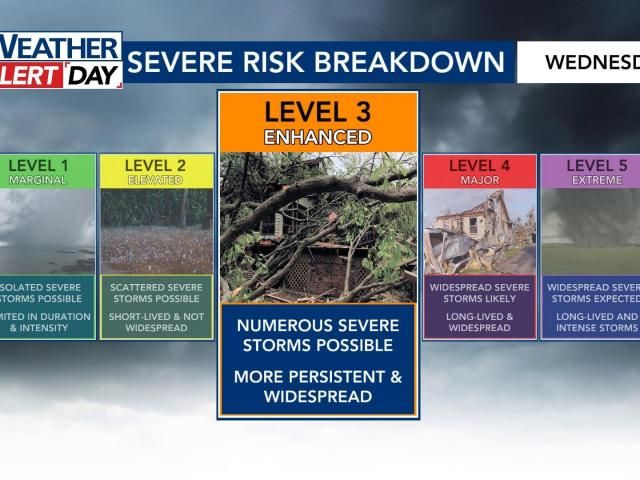
NOAA’s Storm Prediction Center has placed our areas under a Level 3 risk out of 5 for severe thunderstorms Wednesday.
The National Weather Service in Raleigh says the last time we had a Level 3 risk on the Day 2 outlook was August 7, 2023.
WRAL reported 80,000 without power in the Triangle from that day.
Granted, we hit 90 degrees that day, and there was a lot more lightning with that line of storms. It’s unlikely we see 80,000 without power this time around, but we discuss power outages below.
This has increased since Monday. A Level 3 indicates that ‘numerous’ reports of severe weather damage will happen.
Wind damage from straight-line gusts is of growing concern as of this latest outlook.
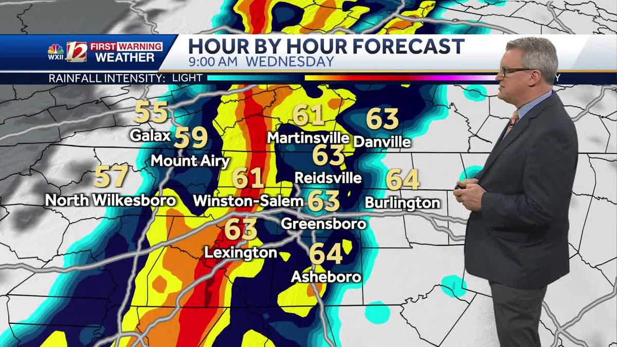
This will be a line/a broken line of showers and storms that moves from west to east between about 8 a.m. and 2 p.m.
Areas west of Raleigh can expect the worst of the weather to start by 10 a.m. This will move east through 2 p.m., and it will be out of our area for the evening commute.
A few isolated storms will be possible during the evening, but the “main event” will be late morning/early afternoon.
We’ll stay windy at times into Thursday, as our area of low pressure swirls to the north.
FutureCast relies on short-term, high-resolution data. We’ve got a first look at that Monday morning, and it updates every six hours.
I’ve split it up into four panels below to give you an estimate of the timing.
In a case like this, damaging wind gusts are the main thing we’ll track. In fact, that threat has increased since Monday. There is some rotation in the atmosphere, so we cannot completely rule out a tornado. That threat is low but not zero.
We are not expecting widespread, large hail or flooding at this time.
Given the potential for damaging wind gusts, I would say that power outages are of potential concern. We saw that happen a few Sundays ago when a similar line pushed through Central North Carolina and knocked out power to thousands.
NOAA’s Storm Prediction Center indicates that scattered gusts of 75 mph will be possible throughout the Carolinas.
A watch means that something is possible/conditions are favorable within the next few hours. This is when you prepare.
A warning means that something is imminent or currently happening. This is when you take action.
A lot of times, we’ll use the acronym SLIM to diagnose severe weather possibilities.
This acronym stands for:
Shear – the changing of winds with both speed and height. This helps maintain storms as the move west to east.
Lift – rising air in the atmosphere allows storms to develop and precipitation to get going.
Instability – storm fuel for thunderstorms to reach their fullest potential.
Moisture – this needs no explanation.
There is plenty of wind shear in the atmosphere to allow for strong wind gusts. The instability is questionable, which could be a limiting factor in our severe potential.
You’re rooting for an earlier start time. That would prevent the atmosphere from warming and becoming unstable.
This is always a challenging question to answer. If you plan on flying to Houston, Chicago, St. Louis, Kansas City, Memphis, etc. on Tuesday, you may very well have some delays. In terms of our weather, I could see there being at least brief delays at RDU as the line passes through, but I cannot speak to cancellations.
This is again one of those questions that I cannot entirely answer, since we’re not involved in those decisions. I will say that the worst of the weather looks like it would come in after bus stop time.
I have seen school systems amend schedules or after-school programs in the past when there’s the potential for severe thunderstorms.
Download the WRAL News app.
Watch our coverage on WRAL News+.
If a tornado warning is issued, we will be live in continuous coverage on all platforms.
Local news & alerts
Copyright 2025 by Capitol Broadcasting Company. All rights reserved. This material may not be published, broadcast, rewritten or redistributed.
What is our risk level for severe thunderstorms Wednesday?
What does a “Level 3” risk of severe weather mean?
When is this expected to happen?
Can you show us FutureCast?
What are the main threats?
Are power outages a concern?
What is the difference between a watch and a warning?
Is there any way this changes, and we don’t get severe storms?
I have a flight. Do you expect delays?
Do you expect changes to school schedules?
How do we get warnings?
Related
VIDEOS
•CREDITS
Around the Web
Controversial Mistake in Estonia Makes Thousands of People Rich
Stop Information Overload
Seeking to avoid repeat of Supreme Court election lawsuit, NC lawmakers eye changes for overseas voters
Raleigh mass shooting: Security company, HOA want families’ lawsuit thrown out
Wake Forest woman almost misses out on $15,600 prize, thinking it was a scam
Is My Space a Good Fit for Airbnb?
Tired of Cleaning out Your Gutters? Get a Quote Today!
Find Local AC and Heating Repair Services
Get Ready to Rethink Your Workplace Shoe Game
Get Personalized Mortgage Advice Close to Home
We’ve Got Your Eyes Covered – Find Your Perfect Pair!
8 Reasons Your Car Insurance Rate Changes
The Surprising Link Between Your Pillowcase and Aging
Stop Paying Too Much for Your Prescriptions – Compare Prices Today
Achieve Total Peace of Mind With Ring Devices
WRAL WeatherCenter Forecast
Evening Pick 3 Pick 4 and Cash 5
Powerball Drawing
NCHSAA Board of Directors holds realignment meeting, hears appeals
Sky 5: Traffic backed up for miles in southern Wake County during gas leak
Meteorologist Brian Slocum tells you what to prepare for this week
A powerful storm system over the Southern Plains Tuesday and will push through the South, bringing the threat of high winds and severe weather. There will be a risk of heavy wind damage and brief tornadoes across central North Carolina Wednesday morning.
Meteorologist Brian Slocum tells you what to prepare for this week
Share
Warming up into the middle of the week before strong storms, winds hit the Carolinas
CHARLOTTE, N.C. (WBTV) – Tuesday will start in the mid 30s with highs rebounding back into the mid to upper 60s.
Clouds and winds will be increasing ahead of our next cold front.
First Alert Weather Day: A cold front will bring a strong line of storms through the Carolinas Wednesday morning through afternoon. Severe storms capable of producing damaging wind gusts and a tornado or two will be possible, especially along/east of I-77.
Strong wind gusts will be likely, even outside of the storms, and could reach up to 40mph outside of the mountains!
Behind the front, much calmer and drier conditions will work in for the end of the week. Thursday high temperatures will be back in the upper 50s, but the 60s return by Friday.
Another chance for showers arrives this weekend, with above-average temperatures expected.
Stay tuned for frequent forecast updates!
Download the free WBTV Weather app on your mobile device, to receive weather alerts and get your latest WBTV weather forecast on the go. You can also get the latest weather forecast on Roku and Amazon Fire’s WBTV app.
Copyright 2025 WBTV. All rights reserved.