Major storm batters southern US with high winds, rain, possible tornadoes: Live updates
A large winter storm began its march across the majority of the United States on Tuesday, unleashing powerful winds, large hail, blanketing snow and triggering tornadoes watches across multiple states.
Starting in Texas and heading east, the low-pressure system is expected to spread as far south as Florida and as far north as Pennsylvania and New Jersey, coming up just short of New York City, which may still be in for some thunderstorms.
“It is going to be a very, very windy time for the eastern two-thirds of the nation,’’ AccuWeather meteorologist Alex DaSilva said. “So basically from the Rockies all the way to the East Coast on Tuesday and Wednesday it could be pretty gusty.’’
The storm’s impacts were already being felt widely. In Texas, more than 400,000 homes and businesses were without power Tuesday morning as damaging winds swept through the state. In New Orleans, Louisiana, officials were forced to reschedule Mardi Gras events and shorten parade routes ahead of the storm.
Wind gusts in the most affected areas, figure to reach 60-70 mph and could approach 100 mph in some localized spots, likely resulting in downed trees and power lines that could cause blackouts, DaSilva said. The Southeastern U.S. figures to take the brunt of the impact Wednesday, but even locations at lower risk of severe weather, such as midwestern cities like Chicago, Detroit and Minneapolis, could experience winds of 40 mph and above.
AccuWeather said the storm could impact up to 170 million people across more than 20 states from the southern Plains to the Midwest and East. The outlet expects major flight delays and cancellations to follow as the harsh weather hits airports near large population centers.
The National Weather Service issued tornado advisories for multiple southern Plains states Tuesday morning, including Texas and Oklahoma.
The weather service offices in Tulsa and Norman warned residents of severe storms “capable of producing tornadoes” moving across the southeastern part of the state. Dallas was among the cities in northeastern Texas under tornado watches.
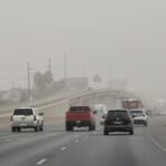
The service’s office in Forth Worth, Texas, warned of the severe weather overnight Monday into Tuesday morning and urged residents to prepare an emergency kit with essentials. The office also alerted of the “critical fire weather’’ in the Dallas area because of the high winds and low humidity Tuesday.
In the Kansas City office of the NWS, forecasts late Monday afternoon were “hammering home the potential for 60-70+ mph wind gusts” over parts of eastern Nebraska, Kansas and west-central Missouri, meteorologist Allan Curtis said.
With the storm threatening to bring powerful wind gusts, hail and possible tornadoes to New Orleans on Fat Tuesday, officials have had to reschedule events and cut some short.
Two of the cities largest parades were set for Tuesday morning, and while they will still occur, the New Orleans Police Department said the festivities must end at 11:30 a.m., before the worst of the storm moves over the area. The parades will also have shortened routes.
“Due to the forecasted inclement weather & high wind gusts, tommorrow’s schedule has changed,” the police department said in a statement Monday. “We’re communicating w/ our partners & will continue to monitor.”
The National Weather Service in New Orleans said the city is at an enhanced risk of severe weather, warning of “damaging winds in excess of 60 mph.”
Through March 2, the U.S. had totaled 61 confirmed tornadoes this year, less than half the yearly average of 138 for that period. That figure is about to change, according to DaSilva, who said the number of twisters is less relevant than where and when they strike.
Nocturnal tornadoes are particularly concerning because they may hit homes when people are sleeping and not ready to seek cover.
“It really only takes one,’’ he said. “If you get one really powerful tornado to go through a very populated area, people are really going to remember that. We just want people to be vigilant.’’
Weather experts across the nation say they fear the Trump administration’s government cuts that resulted in hundreds of employees leaving the National Oceanic and Atmospheric Administration, including the weather service, may increase the threat during these severe weather events.
“Recent terminations within the government workforce for science are likely to cause irreparable harm and have far-reaching consequences for public safety, economic well-being, and the United States’ global leadership,” the American Meteorological Society said Monday.
President Donald Trump and his senior advisor Elon Musk have looked to the Department of Government Efficiency to enact Trump’s signature campaign promise to reduce the size of the federal government.
Most weather service field offices already are understaffed, said James Spann, chief meteorologist for WBMA-TV in Birmingham, Alabama.
“If NWS products and services are reduced, we all suffer … especially during times of life-threatening weather,” Spann wrote in a social media post.
NOAA has said it’s committed to keeping Americans informed about dangerous weather. Spokesperson Scott Smullen told USA TODAY the agency “remains dedicated to its mission, providing timely information, research, and resources that serve the American public and ensure our nation’s environmental and economic resilience.”
In addition to the probationary employees who were dismissed, a wave of senior weather service meteorologists retired Friday, and others left as part of the agency’s “Fork in the Road” plan that will pay them administrative leave through September.
Tornado warnings and watches issued across Texas, Oklahoma
Mardi Gras forced to reschedule events due to severe weather
Major storm threatens nocturnal tornadoes
Forecasters raise alarms about layoffs, budget cuts
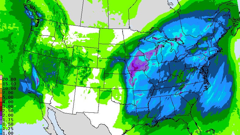
New storm bringing blizzard conditions to Heartland, tornadoes to the South
A strengthening storm system will move across the country this week, bringing blizzard conditions to the Heartland and tornadoes and damaging winds to the South.
On Monday, the storm is focused on the Rockies and the Southwest, bringing mountain snow from Southern California to Colorado.
Meanwhile, there’s an extreme fire danger in New Mexico and western Texas. The combination of gusty winds up to 65 mph and relative humidity down to 5% will make conditions ripe to spread wildfires.
MORE: Evacuations ordered as 175 wildfires erupt across South and North Carolina
As this storm moves east, severe weather will break out across the South starting Monday night and Tuesday morning from Dallas to Oklahoma City.
Damaging winds and a few tornadoes will be the biggest threat.
On Tuesday, the storm will bring dangerous winter weather conditions to the Heartland.
A blizzard warning is in effect for Nebraska, Kansas and Colorado.
Winter storm watches have been issued in Missouri, Iowa, Minnesota and Wisconsin, where more than 6 inches of snow and near-whiteout conditions are possible.
In the South, severe thunderstorms are expected Tuesday afternoon and evening.
Strong tornadoes are possible in Louisiana, Mississippi and Arkansas.
Damaging winds over 60 mph will be possible during Mardi Gras celebrations in New Orleans; Mobile, Alabama; and Birmingham, Alabama.
New storm bringing blizzard conditions to Heartland, tornadoes to the South originally appeared on abcnews.go.com