
FIRST ALERT WEATHER DAYS: From Icy to Winter Storm & Strong Winds
MARQUETTE, Mich. (WLUC) –
A complex slow-moving storm system will result in wet/icy conditions and dangerous travel tomorrow. The first part of this system is bringing a round of rain this morning. It’s combined with temperatures near freezing, which could result in icy surfaces. This is why a First Alert Weather Day remains in effect until 10 am. By this afternoon temperatures increase above freezing, and showers continue in the eastern half. The main low-pressure system lifts out of the Central Plains tonight. Therefore, we will start to have a transition to wet snow in the Western U.P. this evening.
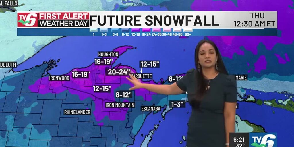
A second First Alert Weather Day will begin at 7pm this evening through 1am Thursday as a winter storm bears down. Wet heavy snow becomes widespread tonight causing sloppy roads tomorrow morning. Then, the snow transitions to drier consistencies as temperatures decreases into the 20s during the day. It will remain widespread through tomorrow evening. We’re expecting dangerous road conditions as winds become strong. Northeasterly winds will have speeds of 20-25 and gusts will range 35-45+mph. Blowing snow will cause poor visibility and white outs near Lake Superior.
Snowfall will be heavy with high accumulations. To begin the lowest snowfall amounts will occur in the Southern Eastern U.P. and along Lake Michigan with a range of 1-3″. A range of 8-12″ of snow will occur for the rest of the U.P. However, the Western and North-Central U.P. will have higher amounts. The Western U.P. will range 12-15″ with 15-18″ in portions of Gogebic, Ontonagon, Houghton and Keweenaw counties. The highest snowfall amounts will range 20-24″ in the higher elevations of Baraga and Western Marquette counties. The city of Marquette will have a range of 12-15″ of snow. If the track of this system changes, we could end up with lower snowfall amounts.
Today: Scattered rain and freezing rain in the morning. Then, snow/rain in the west and rain east
>Highs: Upper 30s west/central, mid to upper 30s east
Wednesday: Widespread wet snow in the morning. Then, a transition to widespread powdery snow temperatures decreases. Plus, strong winds
>Highs: Low 30s in the morning. Then, temperatures decreasing during the day to the mid to upper 20s
Thursday: Light lake effect snow showers in the north during the morning
>Highs: Upper 20s west, low 30s east
Friday: Spotty snow showers in the east
>Highs: Low to mid 20s
Saturday: Partly cloudy and colder
>Highs: Low to mid 20s
Sunday: Scattered snow showers and near seasonal
>Highs: Upper 20s to low 30s
Monday: Morning scattered snow showers
>Highs: Upper 20s to low 30s
Copyright 2025 WLUC. All rights reserved.
SPONSORED
Most Read
Latest News
Looking to Start a Childcare Business? ‘Start Small’ Can Help!
UPDATE: DOGE lists canceled leases for 3 federal offices in UP
1 dead after snowmobile crash in Au Train Township
Man arrested for concealed weapons near Picnic Rocks Sunday; police investigating additional assault claims
FIRST ALERT: Active days ahead from mix to snowstorm
Marquette County man pleads guilty to 9 counts of child sexually abusive activity
CopperDog 150 races finish in Calumet
First Alert Weather Days: Icy overnight-Tuesday AM | Snowy, windy Wednesday
MSP presents corrections officer with award for helping trooper in roadside struggle
First Alert Weather Days: Icy Monday Night-Tuesday AM | Snowy, Windy Wednesday
First Alert Weather Days: Icy overnight-Tuesday AM | Snowy, windy Wednesday
FIRST ALERT: Active days ahead from mix to snowstorm
First Alert: Active days ahead from mix to snowstorm
Warming trend with mixed precip to move in this week
Warming trend with mixed precip to move in this week
Lingering snow showers with warm-up later
40
Some schools have closed or delayed their start Tuesday morning because of icy roads. Check our closing list before you head out!
by Joe Charlevoix
TOPICS:
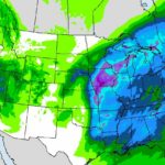
The next round of accumulating snow will arrive late tonight into Friday for parts (but not all) of Northern Michigan transitioning to lake effect into Friday night into part of Saturday. Heaviest snow totals will fall across the Eastern U.P./Straits region. Significantly colder Saturday but it won’t linger as milder temperatures return early next week.
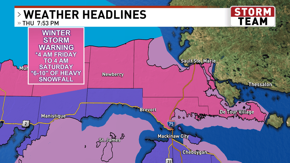
WINTER STORM WARNINGS are in effect for parts of the Eastern U.P. including Newberry and Sault Ste. Marie with WINTER WEATHER ADVISORIES for parts of the Eastern U.P. and Straits region including Naubinway, Petoskey and Cheboygan.
WPBN Default.png
ADVISORY.png
FRIDAY (FEB 28): A more potent clipper drops out of Canada late Thursday into Friday with snow overspreading most of Northern Michigan Friday morning. The heaviest snow will fall across the Eastern U.P. where 6-12″ is possible Friday through early Saturday. The amounts drop as one heads south into the Lower Peninsula with 2-6″ north of a Charlevoix-Gaylord-Alpena line and an inch or less south of there. By the afternoon we may see some rain mixing in or switching completely over to rain for a time and in parts of the Northern/Central Lower Peninsula it could be dry with a few peeks of sunshine Friday afternoon for a time. Highs will range from the 20’s north to 40’s south. South to NW wind 20-30 mph with gusts to 40 mph expect a SE to NE wind across the Eastern U.P.
DMA HRRR SNOW FORECAST.png
SATURDAY (MAR 1): Significantly colder Saturday with ongoing lake effect snow expected for some spots. In particular lake effect snow will hang on near Lake Michigan from the Leelanau Peninsula south including areas around Grand Traverse Bay and Frankfort/Manistee/Ludington as well as across the U.P. in areas along/west of Interstate-75. Elsewhere mostly cloudy. Daytime highs will only reach 14-20F. NNW wind 15-20 with a few higher gusts.
SUNDAY (MAR 2): Quiet and a tad warmer compared to Saturday. Maybe a few flurries but a partly/mostly cloudy sky is in the forecast overall. High temperatures will reach 25-28F.
EXTENDED FORECAST: Longer range weather model guidance suggests a deepening storm system in the heart of the country Monday will lift toward the area in the Tuesday/Wednesday/Thursday timeframe with what could be rain or a wintry mix turning back over to snow.
-Meteorologist Joe Charlevoix
HEALTH
DEALS
STATION
LAWMAKERS
LEGAL
TRENDING
NEWS IN PHOTOS: “Local”
Special weather statement for Northern Michigan Tuesday morning
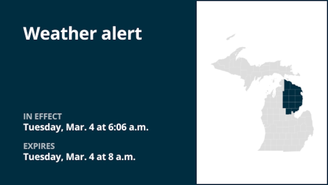
A special weather statement was issued by the National Weather Service on Tuesday at 6:06 a.m. EST until 8 a.m. EST for Cheboygan, Presque Isle, Otsego, Montmorency, Alpena, Crawford, Oscoda, Alcona, Roscommon, Ogemaw, Iosco, Gladwin and Arenac counties.
“If traveling this morning, be alert for slick spots on area roads as a brief period of freezing rain fell overnight. More showers arriving over the next couple of hours may continue to fall as freezing rain, especially across interior parts of northeast lower Michigan where temperatures are hovering at 32 degrees. Untreated and snow-packed secondary roads are expected to be the most icy. Motorists are encouraged to slow down and allow extra time to reach their destination,” says the weather service.
If you purchase a product or register for an account through a link on our site, we may receive compensation. By using this site, you consent to our User Agreement and agree that your clicks, interactions, and personal information may be collected, recorded, and/or stored by us and social media and other third-party partners in accordance with our Privacy Policy.
Use of and/or registration on any portion of this site constitutes acceptance of our User Agreement, (updated 8/1/2024) and acknowledgement of our Privacy Policy, and Your Privacy Choices and Rights (updated 1/1/2025).
© 2025 Advance Local Media LLC. All rights reserved (About Us).
The material on this site may not be reproduced, distributed, transmitted, cached or otherwise used, except with the prior written permission of Advance Local.
Community Rules apply to all content you upload or otherwise submit to this site.
YouTube’s privacy policy is available here and YouTube’s terms of service is available here.
Ad Choices